Monday 31 October 2011

45° imagery available for new 24 cities

This month’s update to 45° imagery in Google Maps includes coverage of more U.S. and international cities, particularly in Spain. 

For example, Girona, a city in the autonomous region of Catalonia and close to the French border, has many historical monuments in the city center. One of these monuments, Santa Maria Cathedral, features several different architectural styles because it was erected during a period of more than 400 years, beginning in the 14th century. 


View Larger Map

Another new city with 45° imagery is the city of Merida, the capital of the autonomous region of Extremadura. The city is a Roman foundation for military veterans and is full of monuments around 2,000 years old such as two Roman bridges, an amphitheater, the Circus Maximus (a horse race track), a Roman theatre, temples and more. 


View Larger Map

In the U.S. we expanded coverage to cities such as Knoxville, Little Rock, Reno, Spokane, and Tallahassee to name a few. Little Rock, the capital of Arkansas, features a statehouse similar to the Capitol in Washington. The city was founded in 1812 by William Lewis but archaeological research indicates the area was settled by Native Americans much earlier. 


View Larger Map

Here is a complete list of updated cities: 

Augusta, GA; Badajoz, Spain; Boise, ID; Boston, MA; Fairfield, CA; Girona, Spain; Knoxville, TN; Lausanne, Switzerland; Little Rock, AR; Lodi, CA; Merida, Spain; Modesto, CA; Montgomery, AL; Murrieta Hot Springs, CA; Provo, UT; Reno, NV; Salem, OR; Sebastopol, CA; Spokane, WA; Tallahassee, FL; Vacaville , CA; Vallejo, CA; Victorville, CA; Wichita, KS; Yucaipa, CA; 

Sunday 30 October 2011

Google Wallet: Now you can pay AND save in a single tap.

Put the country that paying with your phone is a little like magic. Just look at the ecstatic reaction on the faces of our friends who made their first Google Wallet purchases last Thursday. Today, our partners American Eagle Outfitters, The Container Store, Foot Locker, Guess, Jamba Juice, Macy’s, OfficeMax and Toys“R”Us are rolling out an even better Google Wallet experience. For the first time ever in the U.S., at these select stores, you can not only pay but also redeem coupons and/or earn rewards points—all with a single tap of your phone. This is what we call the Google Wallet SingleTap experience. With Google Wallet in hand, you can walk into a Jamba Juice, American Eagle Outfitters or any other partner store. Once you’ve ordered that Razzmatazz smoothie or found the right color Slim Jean, head straight to the cashier and tap your phone to pay and save—that’s it. You don’t have to shuffle around to find the right coupon to scan or rewards card to stamp because it all happens in the blink of an eye. The Offers tab in Google Wallet has been updated to include a new "Featured Offers" section with discounts that are exclusive to Google Wallet. Today, these include 15% off at American Eagle Outfitters, 10% off at The Container Store, 15% off at Macy’s and an all-fruit smoothie for $2 at Jamba Juice. There are many more Google Wallet exclusive discounts to come, and you can save your favorites in Google Wallet so they’ll be automatically applied to your bill when you check out.
Organizing loyalty cards in your wallet is getting easier too. Today, Foot Locker, Guess, OfficeMax and American Eagle Outfitters are providing loyalty cards for Google Wallet so you can rack up reward points automatically as you shop. More of these are on the way. One more thing—in response to user feedback, we’ve improved transaction details for the Google Prepaid Card with real-time transaction information including merchant name, location, dollar value and time of each transaction. Here’s what it looks like:
 
Finally, a special thanks to Chevron, D’Agostino, Faber News Now, Gristedes Supermarkets and Pinkberry who are now also working to equip their stores to accept Google Wallet. It’s still early days for Google Wallet, but this is an important step in expanding the ecosystem of participating merchants to make shopping faster and easier in more places. If you’re a merchant and want to work with us to make shopping easier for your customers and connect with them in new ways, please sign up on the Google Wallet site. And if you’re a shopper and want to purchase a Nexus S 4G phone from Sprint with Google Wallet, visit this page.

Saturday 29 October 2011

In the Zome with Rob Bell

  Rob Bell first introduced us to the Zome during BaseCamp 2008 at the appropriately named Cool SketchUp Stuff session. Last spring, we ran into Rob again at Maker Faire Bay Area. Being fascinated with the evolution of these geometrically hypnotic structures, we thought it would be worthwhile to share Rob’s story and learn more about his new Zome Builder plugin for SketchUp and SketchUp Pro.     About Rob Rob has had an impressive professional career working as a Software Engineer on projects such as Living Books and Lego Mindstorms. More recently he has also done commercial design and fabrication work for companies such as Tesla Motors, Google, The LongNow Foundation and the Stanford Design School. As Rob explained to us, “the type of skills and thinking that make someone a good software engineer are the same skills that make a solid craftsman, designer and builder.”
The Zomadic Shop on a typical day  In 2006, Rob used these skills to start Zomadic, a design/fabrication studio in San Francisco’s Mission District. In his studio, Rob uses SketchUp Pro and his Shopbot CNC router for 95% of his projects. “For me, Sketchup and the Shopbot go hand in hand,” says Rob. What are Zomes Zomes are polar zonohedral domes. Rob’s Zomes are beautiful, organic spaces designed in SketchUp, fabricated with a CNC router and assembled with just mallets and bare hands.
A Zome at Burning Man [photo credit: Dark Sevier]  Properly, Zomes are composed of rhombic faces rather than triangulated struts and nodes.
Looking up the polar axis of a twelve frequency zome  As Rob tells it, “Zomes are about thinking of space and structure in terms of volumes - not points, nor lines, nor planes - because volumes are real and those other things are only abstractions. As Buckminster Fuller said, ‘All systems are polyhedra.’” Designing Zomes with SketchUp Pro For Rob, the first step in creating a Zome is designing the structure in SketchUp Pro.
  The Miracula Mirabilis: A twelve frequency helical zome spire designed in Sketchup.  “SketchUp Pro has been the perfect design tool for me.” Rob continues, “I make strong use of components, layers and component instance transformations. The recent addition of the Solid Modeling Tools to SketchUp Pro has cut down my design time tremendously." To make the design process easier, Rob also wrote a Ruby Script to generate basic polar zonohedral forms, which he subsequently released freely for anyone who’d also like to create these unique shapes.
  Creating polar zonohedra and helical shells in Sketchup  And now Rob has released a new plugin for Sketchup and SketchUp Pro called Zome Builder. Zome Builder generates not just the primitive geometry of a Zome, but it also generates the part geometry that one needs in order to be able to actually build one. It’s a neat tool, which Rob continues to develop.
  The vertex connectors cut on the Shopbot CNC Router 
  Fresh panels being test fit at Zomadic  Once Rob lands on a design, he uses Zome Builder to generate the part geometry for the panels and connectors. The parts are then ready for export to CAD for toolpathing and fabrication using a Shopbot. After the parts are cut there’s still plenty of hand work to be done; subassemblies, edge round over, sanding and painting. Rob’s Zomes are large works of art and the attention to detail is evident to everyone who encounters them. “For this year’s project I had a core team of ten people. Everyone participated in the shop and on the playa to help me make it happen.”
  The Zonotopia crew  The final step is assembly. The joinery of Zomes require no glue, nails, or staples. “I wanted to design a system where everyone could participate and have fun during the construction process,” says Rob. Zomes, Zomes everywhere Rob’s Zomes have been featured at Maker Faire, Lightning in a Bottle, Day of the Dead Festival, Prepare for the Playa, Decompression and of course, Burning Man where each year, he shares a new version of his ever-evolving art piece, Zonotopia. In his words, “I think of Zonotopia as an archaeological wonder of ancient origin built by a people whose skill in art, craft and design was more sophisticated than our own. Each year I’m able to unearth a little more of what’s down there a new and amazing property of this Zonotopal architectural space is revealed and manifested. The Miracula Mirabilis is the third Zome of Zonotopia and it is the most sophisticated so far.”
  The Miracula Mirabilis  “What I find so compelling is that this Zonotopal Architectural space I’m working in has just barely been explored in the computer much less actually built. There are but a handful of people around the world working in this domain -- and a rich domain it is, and that’s exciting.” We’d like to the thank Rob for sharing his one-of-a-kind SketchUp Story story with us. We hope this post inspires you to try Rob’s Zome Builder plugin to make your own Zome. To find more pictures, models and information about Zomes, visit Rob’s website www.zomadic.com and Zomad’s 3D Warehouse page.

Friday 28 October 2011

Explore rendered models in real time with LumenRT

Plain ol' SketchUp lets you walk, run or crawl around your model till your fingers fall off, but you’re limited to SketchUp’s selection of non-photorealistic rendering styles. Pushing your model through a fancy rendering engine can make it deliciously photograph-like, but then you’re stuck with a single image or a pre-baked path in the form of an animation. Now you can have your cake and eat it, too. LumenRT Review for SketchUp (by the good people at e-on Software) is a tool for turning your models into interactive, photo-rendered environments. The output is a stand-alone file — a whole mini application, really — that anyone can open and explore like they’re in a video game. Take a look at this video to see how the navigation works: The results are really pretty incredible. The LumenRT Downloads page includes a number of sample “LiveCubes” (self-contained 3D environments) that you can download and explore at your own pace. One of my favorites features Tadao Ando’s Church of the Light; here’s a video of the LiveCube on YouTube: The computer specs necessary for creating and viewing LiveCubes aren’t minor, but serious SketchUp modelers are likely to be alright. The really good news is that LumenRT is available for both Windows and Mac, and it works with both the free and Pro versions of SketchUp 7 and 8. Licenses cost US$295, but they’re only $195 for a limited time.

Thursday 27 October 2011

Google decided to shut down some products

We aspire to build great products that really change people’s lives, products they use two or three times a day. To succeed you need real focus and thought—thought about what you work on and, just as important, what you don’t work on. It’s why we recently decided to shut down some products, and turn others into features of existing products. Here’s the latest update on what’s happening:
  • Code Search, which was designed to help people search for open source code all over the web, will be shut down along with the Code Search API on January 15, 2012.
  • In a few weeks we’ll shut down Google Buzz and the Buzz API, and focus instead on Google+. While people obviously won't be able to create new posts after that, they will be able to view their existing content on their Google Profile, and download it using Google Takeout.
  • Jaiku, a product we acquired in 2007 that let users send updates to friends, will shut down on January 15, 2012. We’ll be working to enable users to export their data from Jaiku.
  • Several years ago, we gave people the ability to interact socially on iGoogle. With our new focus on Google+, we will remove iGoogle's social features on January 15, 2012. iGoogle itself, and non-social iGoogle applications, will stay as they are.
  • The University Research Program for Google Search, which provides API access to our search results for a small number of approved academic researchers, will close on January 15, 2012.
In addition, later today the Google Labs site will shut down, and as previously announced, Boutiques.com and the former Like.com websites will be replaced by Google Product Search. Changing the world takes focus on the future, and honesty about the past. We learned a lot from products like Buzz, and are putting that learning to work every day in our vision for products like Google+. Our users expect great things from us; today’s announcements let us focus even more on giving them something truly awesome.

Wednesday 26 October 2011

Google Maps Imagery Update

The Google Earth and Google Maps Imagery Team has published their latest batch of aerial and satellite imagery! 
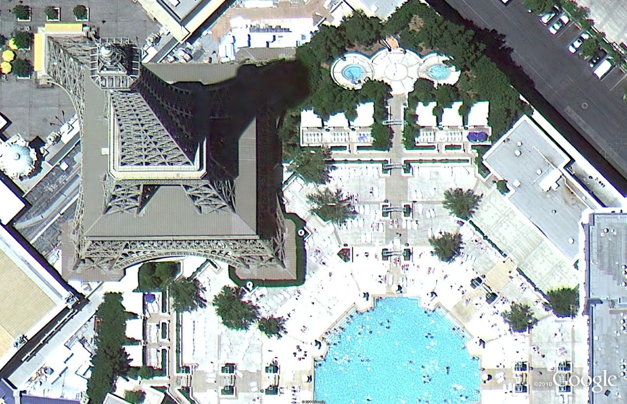
In this blog post, we’d like to highlight a few interesting features from across the globe that can be explored in this new imagery release. Our first example below is of high-resolution aerial imagery from this past June and shows the U.S. version of that instantaneously recognizable French icon, the Eiffel Tower. This half-scale replica is 165 meters tall and spans the Paris Las Vegas Hotel and Casino in Las Vegas, Nevada.
Eiffel Tower Replica, Las Vegas
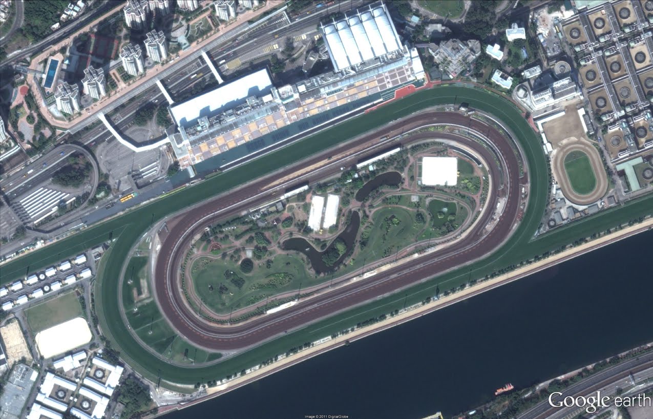
Our next example is of satellite imagery showing the Sha Tin Racecouse in Hong Kong. The 20-acre Penfold Park is situated in the center of the racecourse. The racecourse hosted equestrian events for the 2008 Summer Olympic games.
Sha Tin Racecourse and Penfeld Park, Hong Kong
Finally, here’s a really cool view of the toe of a valley glacier emanating from a small ice sheet in Greenland. This satellite image shows the classic “U-shaped” profile of valleys carved and formed by glaciers. This valley is located southeast of Nuuk, Greenland’s largest city and capital.
Valley glacier perspective view, Greenland
If you’d like to receive an email notification when the Earth and Maps Imagery team updates your favorite site(s), we’ve got just the tool: The Follow Your World application! These are only a few examples of the types of features that can be seen and discovered in our latest batch of published imagery. Happy exploring! High Resolution Aerial Updates: USA: Apache Junction, AZ; Dodge City, KS; Lake Tahoe/Reno, NV; Las Vegas, NV; Los Banos, CA; Midland, TX; Pecos, TX; Stockton, CA Australia: Adelaide UK: Bridgend, Port Eynon Countries/Regions receiving High Resolution Satellite Updates: Albania, Algeria, Angola, Antarctica, Argentina, Armenia, Aruba, Australia, Azerbaijan, Bangladesh, Benin, Bhutan, Bolivia, Bosnia-Herzegovina, Botswana, Brazil, Brunei Darussalam, Bulgaria, Burkina Faso, Cameroon, Canada, Central African Republic, Chad, Chile, China, Colombia, Comoros, Croatia, Cuba, Cyprus, Côte d'Ivoire, Democratic Republic of the Congo, Democratic Republic of São Tomé and Príncipe, Ecuador, Egypt, Ethiopia, Fiji, Finland, France, Georgia, Germany, Ghana, Greece, Greenland, Guatemala, Guinea, Guyana, Honduras, Hong Kong, Hungary, Iceland, India, Indonesia, Iran, Italy, Jamaica, Japan, Jordan, Kazakhstan, Kenya, Kuwait, Kyrgyzstan, Laos, Lesotho, Liberia, Lithuania, Madagascar, Malawi, Mali, Mauritania, Mexico, Mongolia, Montenegro, Morocco, Mozambique, Myanmar, Namibia, Nepal, Netherlands, New Caledonia, New Zealand, Nicaragua, Niger, Nigeria, North Korea, Oman, Pakistan, Papua New Guinea, Paraguay, Peru, Philippines, Poland, Portugal, Republic of Guinea-Bissau, Republic of Korea, Romania, Russia, Saudi Arabia, Senegal, Serbia, Solomon Islands, Somalia, South Africa, South Georgia / South Sandwich Islands, Spain, Sri Lanka, Sudan, Swaziland, Syria, Taiwan, Tajikistan, Tanzania, Thailand, The Bahamas, Togo, Tonga, Tunisia, Turkey, Turkmenistan, Uganda, Ukraine, United Arab Emirates, United Kingdom, United States, Uruguay, Uzbekistan, Venezuela, Vietnam, Western Sahara, Yemen, Zambia, Zimbabwe

Tuesday 25 October 2011

SketchUp Geo-modeler: Guillaume Godin

Guillaume Godin is an accomplished geo-modeler based in Montréal, Canada. He has 157 models uploaded to the 3D Warehouse so far. Of those, 86 are geo-located and 72 have been accepted into Google Earth. Thank you for your contributions and keep up the great modeling, Guillaume! I am a 3D designer and Google SketchUp freelancer. I studied administration in college and now work in publicity for a small firm. I found out about 3D buildings in Google Earth by downloading the application and using it. I started modeling because Google SketchUp is free to download and I thought I might be talented doing it.
L'édifice Grand Tronc on Rue McGill in Montréal
When i started modeling six years ago, I really liked the fact that you have the possibility to publish on Google Earth and then millions of persons can see YOUR building.That really pushed me to do better and better. It really frustrated me for a while not to be able to place photo textures on faces.
Église Saint-Pierre on Rue de la Visitation in Montréal
The first thing I do when I’m geo-modeling is to choose a location with a Google Earth snapshot, then I trace the contour of the building in SketchUp. The third thing I do is to place the axes of the model. Next, I make a group, push/pull up my footprint, then I use Street View to check the approximate height of the building I’m working on.
Le Marché Maisonneuve (Maisonneuve Market) at Place Gennevilliers Laliberté in Montréal
Farine Five Roses is my favorite model because of the sign on top which is a unique feature in Google Earth and in Montreal's Old Port also.
Farine Five Roses (Five Roses Flour) at the Old Port in Montréal
I'd like to make Montreal and its surrounding areas more visible to the rest of the world and let people who are using Google Earth be able to use Street View to see my buildings.
1253 Rue McGill College, where Google’s offices in Montréal are located
I think the Google team have developed such nice and free tools for 3D that anyone with absolutely no experience can become a good modeler.

Monday 24 October 2011

Calling from Gmail with lower rates

We’re always trying to make it easier for people to connect—whether that means sending an email, chatting or video chatting, you can reach the people you care about from right inside Gmail. Last year, we made it possible for those of you in the U.S. to call any mobile phone or landline directly from Gmail and starting today, we are making this available to many more of you who use Gmail outside the U.S. by offering calling in 38 new languages. You can now buy calling credit in your choice of four currencies (Euros, British pounds, Canadian dollars or U.S. dollars) and there are no connection fees, so you only pay for the time you talk. To help reduce the cost of staying connected, we’re also lowering our calling rates to over 150 destinations around the world. For example, it’s now only $0.10 (or €0.08) per minute to call mobile phones in the U.K., France or Germany (landlines are $0.02/min), $0.15/minute to call mobile phones in Mexico and $0.02/min to call any phone number in China and India. The complete list is available on our rates page. We’re rolling out this feature over the next few days, so if it’s available in your country you’ll see a little green phone icon show up at the top of your chat list and you’ll be ready to make calls (you’ll need to install the voice and video plug-in if you haven’t already). If you're a Google Apps user, your domain administrator must have Google Voice and Google Checkout enabled in the administrator control panel in order to be able to use this feature.
Calls to the U.S. or Canada placed within those countries will continue to be free at least for the rest of 2011. Calls to the U.S. or Canada placed from outside these countries will be charged $0.01 per minute (or €0.01, £0.01, C$0.01 per minute).

Sunday 23 October 2011

The Supported fisheries at Google

Over time, it became evident to me that this part of our food supply is broken: many consumers purchase stale, unsustainably-raised fish from chain grocers. Meanwhile, fishermen often sell their diminishing catch to wholesalers at a very low profit, meaning their livelihoods are no longer sustained by their catch. There’s also the environmental factor to consider: Overfishing and illegal practices cause worldwide decline in ocean wildlife populations and wreak havoc on underwater habitats—not to mention the carbon footprint of transporting seafood far from its origin. Google’s chefs have long been committed to sourcing food for our cafes as locally, seasonally and organically as possible. And in our Mountain View headquarters, many employees cook with the same ingredients at home thanks to on-site Community Supported Agriculture (CSA) programs. When I joined the team as an executive chef in Mountain View, I wanted to make a difference in our purchasing program for seafood. For the five years leading up to then, I wrote a column for the San Francisco Chronicle called “Seafood by the Season,” and I knew it could be done. In early 2010, we began a push to apply the most rigorous standards to our seafood-buying practices, and respond to the in-the-moment fluctuations of the catch from small, independent fishermen. Things took off from there. My colleague Quentin Topping dreamed of providing the same high-quality seafood we serve in our cafes for Googlers to take home to their families. That idea became the Google Community Supported Fishery (CSF), which we launched in May 2011. In this program, Googlers sign up to purchase a weekly supply of local, sustainable seafood, supplied through a partnership with the Half Moon Bay (HMB) Fisherman’s Association.
The Google Culinary team on a visit with fishermen in Half Moon Bay, Calif.—Quentin and I are the second and third from the left, in black.
We tend to think on a massive scale at Google—whether it’s how to deliver instant search results around the globe or help thousands of small businesses get online—but when it comes to feeding our employees at work and at home, it really comes down to a local touch. Knowing where our seafood, meat and produce come from, as well as knowing how they’re raised, farmed or harvested, makes all the difference in the on-the-ground work of sustainability. We see many bright spots ahead for our Community Supported Agriculture and Fishery programs, such as expansion to other offices and adding a grass-fed beef and pasture-raised poultry program. It’s exciting to work someplace where we can think big and local. We know of two CSFs in the Bay Area. The Half Moon Bay Fishermen’s Association supplies only Google at the moment, but will soon add public drop-off sites—keep posted by visiting Farmigo.com. The other is CSea out of Bodega Bay. If you live elsewhere, we hope you’ll consider stepping up to create one in your area. And even if you don’t live near the ocean or have direct access to fresh-caught seafood, the choices you make about what fish to purchase or order in restaurants can make a real difference. You may want to consider following the guidelines that we used for our Google Green Seafood policy: Whenever possible, purchase species caught locally and in-season, by small, independent fisher-families, using environmentally-responsible methods. We think it’s important to be responsive to the fluctuations of catch too, and source from fisheries that enforce catch limits or are guided by ecosystem-based management programs. As for us, we’ll continue to research and source responsibly managed farmed seafood, and always keep transparency and Googler health at the center of our program.

Saturday 22 October 2011

Nexus S Comes to AT&T

Since launching Nexus S with Samsung, T-Mobile and Sprint customers have enjoyed the pure Google experience, running the latest Android releases and Google mobile apps. Today we’re excited to announce a Nexus S device optimized for AT&T, available in Best Buy stores this weekend. Nexus S runs Android 2.3 and features a 4” Super AMOLED screen, a 1 GHz processor for showing 3D graphics, front and rear facing cameras and support for NFC. It also features the latest Google mobile apps, including Google Earth, Google Maps with Navigation, Google Talk with video chat, Google Voice and Voice Actions, as well as access to more than 250,000 apps in Android Market. Nexus S for AT&T will be available in Best Buy stores starting July 24. For those of you who just can’t wait, it’s on pre-sale today in Best Buy stores. You can find more information at google.com/nexus or follow @googlenexus on Twitter for the latest Nexus S updates. And if you need something to pass the time until you can get your hands on one, try our Nexus Contraptions game, where you can bubble, bounce, and bump apps into the phone.

Stay safe around the world

A security feature called 2-step verification that helps protect your Google Account from threats like password compromise and identity theft. By entering a one-time verification code from your phone after you type your password, you can make it much tougher for an unauthorized person to gain access to your account. People have told us how much they like the feature, which is why we're thrilled to offer 2-step verification in 40 languages and in more than 150 countries. There’s never been a better time to set it up: Examples in the news of password theft and data breaches constantly remind us to stay on our toes and take advantage of tools to properly secure our valuable online information. Email, social networking and other online accounts still get compromised today, but 2-step verification cuts those risks significantly. We recommend investing some time in keeping your information safe by watching our 2-step verification video to learn how to quickly increase your Google Account’s resistance to common problems like reused passwords and malware and phishing scams. Wherever you are in the world, sign up for 2-step verification and help keep yourself one step ahead of the bad guys. To learn more about online safety tips and resources, visit our ongoing security blog series, and review a couple of simple tips and tricks for online security. Also, watch our video about five easy ways to help you stay safe and secure as you browse.

Friday 21 October 2011

New style for Google Maps

There is a good chance that you haven’t noticed subtle changes to cartographic design of Google Map that the company is continuously implementing. However, if you put different versions of Google Map side by side, it becomes very obvious how dramatically the appearance changed over the last few years. The key objective behind those changes is “… to make the map cleaner, more focused, more visually harmonious, and easier to use.…Some highlights to look out for are a brighter and more cheerful colour palette, a more integrated and less visually noisy labelling style, subtle improvements to footpaths and minor roads, and cleaner building and land parcel rendering.” One thing Google cannot be accused of is that it does not put continuous efforts into upgrading of its products and services. In fact, that constant tinkering with features and functionality gives an impression that all Google products are in a permanent state of development. With Google we never know what functionality is coming and when it will be available, or whether the product or service will survive in the long run as the company is not afraid to pull down underperforming applications. The most recent announcement is the closure of Google Labs with 56 experimental products. Product-specific Labs sites, like Gmail Labs, Google Maps Labs and Search Experiments, aren't affected by the decision.  

Thursday 20 October 2011

The Two Maps

Two Maps: In this post I'm going to look at two maps of Southampton. The post is not a criticism of the authors mentioned, both the sets of people who come up in this post deserve praise for their work in different ways. My point is that from a user centered view we could incorporate parts of both of them to make a 3rd better map.
The Problem and Current Solutions: Visitors to my workplace, Southampton University, have to find their way to the various buildings on campus for meetings, open days and the like. To do this they can use the official map (referred to from here on as the 'cartographer's map' and which won a cartographic award) but they can also access a more recently published interactive map produced by the open data service which is based on data from the open data service, this is a project based within Southampton that aims to get the various services within the uni to open up data they have for reuse on the web.
Cartographer’s map: This was done by my colleagues in Geography in the Cartographic unit (as was) who were tasked with producing a static map of Highfield campus. Its a lovely piece of work, the stylised 3D view is elegant. It also allows users not only to orient themselves via building’s footprints but also by using tall buildings such as the maths building (NW side of campus) as landmarks which wouldn't be possible with a true 2D map. Overall it works wonderfully as a static paper map and its available from the Uni website as a PDF where users can print it out for carrying around on campus. Of course this is only one possible use, for planning a visit we could improve upon the static original by making it interactive with features such as: 
  • Searchable buildings: enter a building name to get back its location (and visa versa)
  • Layers that can be clicked on and off such as food outlets, bus stops and car parks
  • Zoomability: Zoom out of one campus (this one is Highfield campus, one of several in Southampton) to view the other ones
Open Data Map: The Open Data service has produced a map which has all the above features, as you type in a search word it also auto completes what you're searching for (I assume via AJAX) and a has a locate me button for use with mobiles. Nice work.
However, because the people who produced it are computer science postgrads they don't know much about cartography and the design is not very good. For instance, we've lost all the trees, window shapes and the 3D view that the cartographer's map had, these features all help the user orient themselves as they can act as landmarks. Also the way the icons are grouped in the key makes them unreadably small. Finally, click on a building and you usefully get a pop up balloon with a building photograph, rather less usefully you also find out who the architect was and how old the building is - not much use for your average user wanting to know where to get a coffee.
To be fair to the open data map authors, their drive seems to be about show casing how we can use open data about Southampton University. Good for them, there's a lot of hard work gone into this piece of work collecting the data together and building smart interactivity which makes it a successful experiment. But to produce a useful map suitable for planning a visit smart interactivity and open data isn't enough - usability is key and for this the design has to work as well.
Conclusion: So to come back to my original point, everyone did a good job in producing their maps in the sense that they got the stuff right that they thought was important. However, to be useful for visit planning* we need to consider the user and we could make a better map for them by combining the excellent design of the first map with the interactivity of the second.
 

Wednesday 19 October 2011

Google SketchUp: The Town of Tomorrow

  Westport, Ireland has been holding the Town of Tomorrow competition for a few years now. As the name implies, the competition is about designing a futuristic version of Westport town with Google SketchUp. For this year’s competition, we flew out to Ireland to train students in basic SketchUp modeling techniques.
Students experimenting with SketchUp.  After the training, students spent two and a half months developing their visions of what Westport should look like in the future. We then selected winners based on how innovative, creative, and practical the design was. Many of the students incorporated themes of green technology, renewable energy, and sustainability into their projects.
The winning design from the Electric Spoon Parade team!  This year’s winning design came from the Electric Spoon Parade team and was based predominately on the use of converting the town’s canals to hydroelectric power generators. There were also other water catchment systems set up around the town to collect rain water for greenhouse use and filtered for consumption at a newly designed sports complex. Other important attributes include an underground bypass for automobile traffic and a pedestrian bridge.
Photo courtesy of Conor McKeown  We held a celebration to announce the winners and awarded everyone a variety of fun Google gear, notably the sweet shades the participants are sporting in the photo above. The Town Council of Westport also generously provided gift cards to all the members of the winning teams.

Tuesday 18 October 2011

Map data update for France, Monaco, and Luxembourg

  With over 600,000 sites actively using the Google Maps API, more people around the world view maps provided by the Maps API than any other source. For this reason it’s vitally important that Google Maps provides the most accurate and up to date map data possible. For this reason we're happy to introduce updated maps and the "Report a Problem" tool to France, Luxembourg, and Monaco. As with previous updates in countries such as the U.S.A., Australia, and parts of Europe, this update utilizes a wide range of authoritative sources such as the Institut Geographique National. In addition, the "Report a Problem" tool on Google Maps allows you to let us know if some aspect of the map that needs correcting, and we'll do our best to address it quickly (often within just a few days). These map updates will roll out over the next 24 hours across all our Maps APIs and related services. As with previous updates we do ask that you refresh any data that you have previously obtained for these countries using Maps API Web Services, and cached for use in your Maps API application. If you have any questions or concerns relating to this, please post them to the Google Maps API forums.

Monday 17 October 2011

Google Places: The show is about to begin

  Google I/O 2011 kicked off today, and we have a great line up of sessions on the Geo track. First up this morning was a session on "Connecting people with places", in which we were delighted to announce general availability of the Google Places API. This represents the culmination of the Developer Preview launched last year, shortly after we introduced the Places API at Google I/O 2010. Interest in the Preview was overwhelming and we have been amazed by the innovative use cases suggested for the API. The developers we worked with provided a great deal of extremely valuable feedback on all aspects of the API, including features, performance, usability, and terms of use. We’ve been working hard to implement the recommendations we received during the Preview. As a result the service launching today includes many new features, most of which are a direct result of this developer feedback:
  • A globally consistent type scheme for Places, spanning more than 100 types such as bar, restaurant, and lodging
  • Name and type based query support
  • A significantly simpler key based authentication scheme
  • Global coverage across every country covered by Google Maps
  • Google APIs Console integration, which provides group ownership of projects, key management, and usage monitoring
  • Instant reflection of new Places submitted by an app in subsequent searches made by that app, with new Places shared with all apps after moderation
  • Real time reranking of search results based on current check-in activity, so that Places that are currently popular are automatically ranked higher in searches by your app
In addition to these changes we’re also adding a companion Autocomplete service to the Places API, which predicts the Places a user might be looking for as they type. This service is based on the same technology that powers the search field on the Google Maps website, and can dramatically reduce the amount of typing needed when searching for a known place by name, which is particularly valuable on mobile devices. Both the Places API Search service and the Places API Autocomplete service are offered as XML/JSON REST based web services. These APIs are currently both in Google Code Labs, which means they are not yet included in Maps API Premier. However we are working to graduate the APIs from Code Labs in the near future, at which point the service will also be offered to Maps API Premier developers. To get started, please follow the instructions in the documentation for obtaining an APIs console key, and enabling the Places API on that key. If you have joined us at Google I/O this year, come along to our session on "Building Location Based apps using Google APIs" at 3pm on Wednesday, in which our Tech Lead, Marcelo Camelo, will be diving into the API in more detail. In addition to these web services we are also launching a new places library in the Google Maps API which includes:
  • A PlacesService that allows Places API queries to be issued by Maps API applications
  • A class that can attach Autocomplete behaviour to any text field on a web page, with the predicted places biased to a specific location or map viewport
The below demo uses the PlacesService to display Places on a map in response to changes in the map view port. An individual Place can also be mapped using the Autocomplete enabled search field:   If you would like to provide any feedback about the Places API or Maps API, or you have suggestions for improvements or new features, please let us know using the Maps API Issue Tracker. You can also discuss our APIs using the Maps API Developer Forums. We’re very excited to make all of these great Places services available to all of our Maps API developers today. We know many of you have been eagerly awaiting access to the Places API, and we appreciate your patience. Places bridge the divide between the way that maps and computers represent the world, and the way that people relate to it. We believe that the launch of the Places API will spark a whole new wave of innovative location based application development, both on mobile and desktop, and we can’t wait to see how it is used. Posted by Thor Mitchell, Product Manager, on behalf of the Google Maps API team
 

Wednesday 12 October 2011

The iPhone Siri – The Future Of Local Search?

This is not a tribute to Steve Jobs directly. Although in the end it may be one of his greatest legacies. I have been in the technology field for over 30 years. I have seen a number of radical changes that became metaphors for how things were supposed to be done. Many, but certainly not all, of these metaphors were created at the hands of Steve Jobs. QWERTY defined the keyboard. The Apple II defined a generation of PCs. Sony defined what the home video recorder should be. The Mac defined what a Window and Window based programs should behave like. The iPhone defined how touch functions on a smartphone and what a smartphone is. These defining products and the companies that produce them don’t always win the battle in the market place for various reasons but the idea sticks. The technology becomes iconic and lays the path for others to follow. Sometimes the followers overtake the creators, sometimes the creators win. The market is a brutal overseer. Siri, the natural language interface for the new iPhone 4s, is one such product. It may not be the product that wins the battle in the market place, it may not be the specific product feature that everybody has to have in their pockets in 2015 but if it isn’t, whatever is there will be like Siri. Imagine a world where you say to your phone: Find me the best Asian restaurant within 25 miles. Or: Text my wife to meet me at 21. Or: Schedule an appointment for me with Joe the PR Guy and send him a text. Or: Tell my friends on Facebook that our team won! All of the sudden the only thing that matters is the answer. Nothing else. You won’t be looking at a search box, you won’t be landing on someone’s home page, you won’t be looking at an ad…In fact you won’t be looking at anything. You won’t need to. Not all of your interaction will be voice driven but depending on your mobile needs a large portion of it could be. You no longer need to look at your phone to enter a query in a search box. You just ask for the answer and it will just give it to you. The answer can come from a single source or a range of sources. The brand of search engine is no longer important, the brand of phone that you are asking the question on is. Your only relationship is with the phone. Either it works or it doesn’t. Search engines and web brands could potentially fade in importance. The winner in this next interface battle gets to pick where and who it gets the answer from. If it needs three data sources, it uses three data sources. If it needs four, it looks at four. That complexity is all hidden and the user not only doesn’t need to visit multiple websites, the user doesn’t even need a special app. Siri, or something like it, becomes the great equalizer for data sources. An OS for voice as it were. It handles the complexities. You just need to ask it. Will it do what Apple says it will? There was a time when you couldn’t trust what Apple or any technology firm said. You had to have it proven to you. Even though this is a new Apple, one molded by the demanding perfectionism of Steve Jobs, this is one of those times when you will need to know that the natural language interface works and it works seamlessly. If it does, it becomes THE WAY that you want to interact with the device. The new QWERTY as it were. Maybe not all all the time but certainly with mobile search and more frequently than not with mobile local search. It also become the great disintermediator in mobile. It may be the greatest disintermediator of all time. If it works.

Tuesday 11 October 2011

The Update on Digital Urban

Firstly apologies, the blog has been sat on the sidelines waiting for a post while i have been in a whirlwind of a three weeks. The good news is the blog is back, in short, we have been in the process recently of securing grants, launching a new Masters of Research course here at the Centre for Advanced Spatial Analysis at University College London and presenting current research to the British Science Festival and the associated press conference.
Press Conferences are everything you imagined with the various leading newspapers gathering round and shouting questions. Packing a dress worn by Annie Lennox at Nelson Mandela's Birthday Party, RFID tags and a short presentation based around the Tales of Things work we announced the concept of the Internet of Second Hand Things. 
It was a fun event and we had some excellent coverage with the Financial Times, Sunday Times, Russia Channel One, BBC Radio 4 and BBC Radio 5 amongst the highlights. Mixed into this were two grant bids, one with NESTA and the other for a UCL Enterprise Award. I'm please to say we won them both, opening the doors to work with the Imperial War Museum and Digital Humanities in UCL and continuing the work with the wider TOTeM group to set up TOTeM Labs.
While juggling press requests, conference presentations, grant short listings and interview boards we have welcomed 9 members to our new MRes in Advanced Spatial Analysis and Visualisation - a Masters of Research differs from a traditional MSc as its less jumping through hoops to learn and more focused in becoming part of the research world. We purposely constructed the MRes to be the course we would like to take and as such it is an exciting mix of visualisation, coding, mapping, crowd sourcing, modelling and research methods. If you are thinking of taking a Masters, i would strongly suggest a MRes, it offers something different to everyone else with a MSc and of course sets you up for a PhD. 

WhereCampPHX 2011

  We had the first ever WhereCampPHX in Arizona.  I was very happy with the attendance and after the first jitters of never being to a unconference before, the crowd totally got into it.  In fact, I had many people come up to me after and say they wanted to do another one right away because they had no idea how much fun they can be if you take part.  In what was unique for me at a WhereCamp, there seemed to be two tracks that people created.  One of “traditional” GIS (scripting geoprocessing, map servers, analysis) and then another one that focused on new technologies.  I spent most of my time in the second one where there was discussions on Google Fusion Tables/Google Earth Builder, TileMill, Places APIs, Vectors in the browser (Polymaps, Raphael) and back-end databases.  
Checking the board to see where the next session will be.
It was a nice change of pace to have a WhereCamp in my hometown and not having to travel to another state or country.  The feedback from those who attended clearly shows that there is a need for these more informal sessions as opposed to the traditional conferences.  Having the first one of these here in Arizona gives us a leg up on the next one since most of the crowd now knows what to expect and they can propose their own topics. We also had a great time at the Turf Pub for the after party (thanks Bentley for the food) watching Arizona State fall behind and then blow out Oregon State.  My plans are to have some sort of event (maybe an Ignite style talk program) or another unconference in the spring so we can continue what we’ve started.  Everyone who attended seemed to have their minds filled with new ideas after the day so there needs to be some downtime to implement all the new stuff we’ve learned.  

Related Search Results Moving to Main Search

It appears that on certain search results that Related Places, that have been typically showing at the bottom of a business’s Places page, are being moved to the main search results and showing up under “similar pages” results at the bottom of the page. The new results are not widely returned. I was only able to see local “Pages similar to” on a limited number of locally branded searches for bed and breakfasts in St Augustine & San Francisco but not on similar searches in other markets. Whether this is a test or a permanent feature is unclear. The searches for Chateau Tivoli Bed & Breakfast San Francisco and Bayfront Marin House St. Augustine both show the Related Places removed from the respective Places page (here & here) and have them turning up at the bottom of the main results. Searching for other specific B&Bs in SF and St Augustine returned similarly missing related places on their Place’s Page. But similar searches in many other markets do not. Discussion: Related Pages were added to business’s Place Page in early February 2010 and were originally referred to as Places Nearby You Might Like. Despite their name, they were not liked by business owners as they showed nearby competitors on what many SMBs considered their page. It was the first indication by Google that a Place Page was their search result NOT a small business owned business listing. Google started showing related results at the bottom of the search results in the “Pages Similar To” format in April, 2010. It has typically shown related web pages NOT local web page results. It is hard to tell whether this is new emerging change or a test. Given the low traffic that Place Pages get, moving Related Places to the main search is likely is unlikely to have much  negative impact Google’s lateral traffic. With the attitude of most SMBs towards seeing competitors on “their” page, it makes sense for Google to move “related places” to the main search results. SMB suspicions are easily aroused and they are a prickly lot. When asked by Google to spend ad dollars, it would be much easier for the SMB to say yes without this particular thorn in their side. From the SMB point of view, this is a change that should happen to all Place Pages now

Saturday 8 October 2011

The ATT Suck? Let me count the ways

  If you decided to order a new iPhone 4s today.... I thought that the most hassle free order method was to just go to my local ATT store. It was the obvious choice. There is never a line, the staff is friendly. The affable salesman knows me by first name and is an avid iPhone owner himself. I could be catered to and I wouldn’t have to think too hard. I thought how can I go wrong? Not to worry. With ATT there is always a way. The choices offered by ATT: 1)I could preorder and wait for 3 weeks for delivery or 2)I could come in next Friday and stand in line or 3)Since I am consulting in Phoenix next Friday, I could stand in line there. Yea right. Pulled out my iPhone while standing frustrated at the ATT sales counter & go to the Apple site. It suggested I download the app, which I did. Within 3 or 4 minutes I had preordered my iPhone. I asked my salesperson (who I felt really sorry for) to advise the chain of command of the outcome.

Google Account support and YouTube API v2.1

Authenticated access to YouTube APIs lets your app offer many features that are unavailable to logged-out users. By authenticating user actions, your app can allow users to manage subscriptions, create playlists, and upload videos. Until recently, users could only perform any of these operations if they had YouTube accounts. (A YouTube account provides a user with a YouTube channel.)
We are pleased to announce that we have also started to give Google Account holders who don’t already have YouTube channels access to certain YouTube features on YouTube.com and in the YouTube API. We call these unlinked Google Accounts since they haven’t already been linked to a YouTube channel. For example, a user with a Gmail account or an Android device is certain to have a Google Account but may not have already linked that account to a YouTube channel.
What this means for your application is that with a few relatively simple changes, you should be able to allow authenticated access for users who have unlinked Google Accounts. Thus, those users will be able to log in to YouTube without having to create a YouTube username.
In a moment, we’ll dive into the details of how to use the API with unlinked Google Accounts and also offer a few user experience recommendations for your YouTube API application. First, though, a quick note about the new minor YouTube API revision that we’re introducing.

Thursday 6 October 2011

Getlisted.org Local University on November 1

  Local University is nearing the completion of its second year of SMB education. We just finished up a great session Burley ID with Mike Ramsey. I am incredibly excited that our next Local U event, November 1st, is being held in my backyard in Ellicottville NY at the Holiday Valley Resort . It will feature a presentation by Cecelia Stewart of Google Places. During the session we cover a lot of ground and try to provide SMBs with a framework for either doing the work themselves or hiring it out. Getlisted Local University WNY Like the first Getlisted Local U in Spokane in 2010 there will be two identical 4 hour sessions. The speakers include Matt McGee, David Mihm, Mary Bowling, Ed Reese, Cecelia Stewart and myself. To bring the event to rural Western NY took the cooperation and sponsorship of a large number of profit and non-profit groups. Community Bank, N.A., Cattaraugus County Industrial Development Agency, Cattaraugus County Economic Development Team, Olean Area Federal Credit Union, MetroWNY, Google Places and Holiday Valley have already signed on as corporate sponsors, and several area chambers of commerce have partnered with event organizers to promote the event to their members, including Hamburg, Ellicottville, Olean, Wellsville, Niagara Frontier Tourism Task Force, Chautauqua County, Seneca Salamanca, West Seneca, South Buffalo, Bradford, Pa., and Warren, Pa. Google’s sponsorship allowed GetListed to award 25 free “scholarship” tickets to area college students in related fields. Pricing for the event is $129. If you order the ticket with the discount code MB2011 it will be $89 on an early bird special through October 8th and $99 there after. Head over to Getlisted.org/WNY and order some tickets now. Hope to see you there! If you are thinking of coming in from out of town, Holiday Valley is offering a special rate of $90/night (discounted from $147) to attendees. Simply mention you are attending the GetListed conference when you call (800)323-0020 to place your reservation. While the event is targeted to SMBs, we frequently see other marketers attend. Ellicottville is 3 hours from Toronto, Cleveland & Syracuse and only two from Rochester, NY. If you do decide to come, let me know you are attending so we can try to meet up. We are also planning our 2012 schedule so if you are interested in bringing a Local U to your community, let either David or myself know and we can give you an idea of what is required.

Google JS Test Unit

Google JS Test is a JavaScript unit testing framework that runs on the V8 JavaScript Engine, the same open source project that is responsible for Google Chrome’s super-fast JS execution speed. Google JS Test is used internally by several Google projects, and we’re pleased to announce that it has been released as an open source project. Features of Google JS Test include:
  • Extremely fast startup and execution time, without needing to run a browser.
  • Clean, readable output in the case of both passing and failing tests.
  • An optional browser-based test runner that can simply be refreshed whenever JS is changed.
  • Style and semantics that resemble Google Test for C++.
  • A built-in mocking framework that requires minimal boilerplate code (e.g. no $tearDown or $verifyAll calls), with style and semantics based on the Google C++ Mocking Framework.
  • A system of matchers allowing for expressive tests and easy to read failure output, with many built-in matchers and the ability for the user to add their own. 
See the Google JS Test project home page for a quick introduction, and the getting started page for a tutorial that will teach you the basics in just a few minutes.

Share This Post