Monday, 28 February 2011
Mobile Growing Faster Than “All Our Predictions”- said Google CEO
Mobile use is growing faster than all of Google’s internal predictions, with YouTube seeing 200 million mobile playbacks a day, CEO Eric Schmidt said in his keynote at the Internet Advertising Bureau’s Annual Leadership meeting keynote.
As proof of mobile’s growth, Schmidt cited some statistics related to this year’s Super Bowl advertisers. The number of mobile searches for Chrysler, for instance, jumped 102 times during the game, compared to only 48 times for desktop searches, Schmidt said. And the number of mobile searches for GoDaddy jumped 315 times, compared to 38 times on desktops.
Schmidt, who spoke Sunday at the IAB event in Palm Springs, California, also said that 78% of smartphone owners use their phones while they shop. “This is the future and everyone will adapt,” said Schmidt. “Because people are fundamentally better off with a better and smarter and more empowered, if you will, customer.”
Mobile growth is occurring at a quicker rate than anyone expected, Schmidt said. “We look at the charts internally and it’s happening faster than all of our predictions,” Schmidt said.
Schmidt, who will leave his post as Google CEO on April 4, used those stats to make a case for linking display advertising and mobile. “The technology has finally caught up with the promises we talked about for so long,” said Schmidt. He predicted that display advertising could hit $200 billion business, though he declined to say when that milestone would be reached. Display is currently a $17 billion business globally. Google’s share of that is about $2.5 billion a year.
More Countries, More sellers, More buyers

Since we launched Android and Android Market, we have seen the population of Android users and devices expand into many countries. This widespread adoption has brought with it growing interest in Android Market’s support for the buying and selling of paid applications in these additional countries.
We have been hard at work on this and it is my pleasure to announce that effective today, developers from 20 more countries can now sell paid apps on Android Market. Additionally, over the next 2 weeks, users in 18 additional countries will be able to purchase paid apps from Android Market.
Support for paid application sales is now expanded to developers in 29 countries, with today’s additions of Argentina, Australia, Belgium, Brazil, Canada, Denmark, Finland, Hong Kong, Ireland, Israel, Mexico, New Zealand, Norway, Portugal, Russia, Singapore, South Korea, Sweden, Switzerland and Taiwan.
In addition, Android Market users from 32 countries will be able to buy apps, with the addition of Argentina, Belgium, Brazil, Czech Republic, Denmark, Finland, Hong Kong, India, Ireland, Israel, Mexico, Norway, Poland, Portugal, Russia, Singapore, Sweden, and Taiwan. No action is necessary if you have targeted your paid apps to be available to “All Locations” and would like to launch in these additional countries. If you have not selected “All Locations” and would like to target these additional countries, or if you have selected “All Locations” and do not want to launch your apps in these additional buyer countries, please visit the Android Market publisher site regularly over the next two weeks to make the necessary adjustments as the new buyer countries launch.
We remain committed to continuing to improve the buyer and seller experiences on Android Market. Among other initiatives, we look forward to bringing the Android Market paid apps ecosystem to even more countries in the coming months. Please stay tuned.
Sunday, 27 February 2011
Great British Google Maps Round-Up
Great British Life is a website that celebrates everything that is great about Great Britain. This celebration includes a Google Map that allow readers to browse restaurant reviews, upcoming events and reader's photographs by location.
It is possible to filter the map by 'articles', 'events', 'photos' and 'blogs'. If you click on a map marker you can read a brief review and view ratings. Each window also includes a link to read the full article.
Prolific Google Maps developer Colin Johnson has produced a number of UK based Google Maps under the LiveMaps label.
This Google Map details events in the county of Devon, featuring Town Shows, Carnivals, Farmers Markets etc. The map displays events for the next three months. The map also links to a Devon Live Entertainment page which features the leading theatres and venues in the region, a Devon Attractions site detailing a wide variety of things to do and places to visit and a Devon Holiday Accommodation page.
LiveMap English Football Ground Guide
This Google Map is a guide to the soccer clubs in the top 16 divisions of English football.
LiveMap Roadworks
LiveMap Lincoln Essentials
This Google Map is a directory with a difference. Detailing a range of useful locations such as car parks, cash machines, recycling banks, post offices in the city of Lincoln
LiveMap Wildlife Parks
LiveMap Wildlife Parks plots the location of over 130 zoos, safari parks, butterfly farms and other wildlife attractions throughout the UK.
LiveMap Theatres & Venues
Details hundreds of theatres and live entertainment venues throughout the UK.
Citizens Report UK
Citizens Report UK, a website dedicated to helping citizens improve their personal safety, uses Google Maps to help report on many safety and crime issues in the UK. A couple of weeks ago Google Maps Mania featured the Citizens Report UK map of British Road Casualties 2008 & 2009.
The map makes great use of the Fusion Tables queries function. It is possible to refine the results shown on the map by offence, date and region.

It is possible to filter the map by 'articles', 'events', 'photos' and 'blogs'. If you click on a map marker you can read a brief review and view ratings. Each window also includes a link to read the full article.
Prolific Google Maps developer Colin Johnson has produced a number of UK based Google Maps under the LiveMaps label.

This Google Map details events in the county of Devon, featuring Town Shows, Carnivals, Farmers Markets etc. The map displays events for the next three months. The map also links to a Devon Live Entertainment page which features the leading theatres and venues in the region, a Devon Attractions site detailing a wide variety of things to do and places to visit and a Devon Holiday Accommodation page.
LiveMap English Football Ground Guide
This Google Map is a guide to the soccer clubs in the top 16 divisions of English football.
LiveMap Roadworks
LiveMap Lincoln Essentials
This Google Map is a directory with a difference. Detailing a range of useful locations such as car parks, cash machines, recycling banks, post offices in the city of Lincoln
LiveMap Wildlife Parks
LiveMap Wildlife Parks plots the location of over 130 zoos, safari parks, butterfly farms and other wildlife attractions throughout the UK.
LiveMap Theatres & Venues
Details hundreds of theatres and live entertainment venues throughout the UK.
Citizens Report UK
Citizens Report UK, a website dedicated to helping citizens improve their personal safety, uses Google Maps to help report on many safety and crime issues in the UK. A couple of weeks ago Google Maps Mania featured the Citizens Report UK map of British Road Casualties 2008 & 2009.
Interactive Map of Recorded Offence

The map makes great use of the Fusion Tables queries function. It is possible to refine the results shown on the map by offence, date and region.
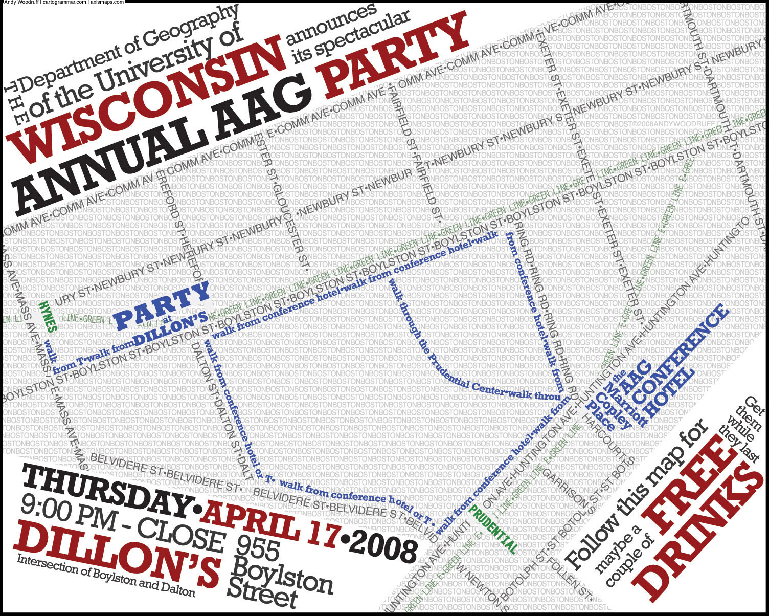
Typographic map posters
Today we’re pleased to show off a pet project that’s been occupying us off and on for nearly two years. After some emotional separation issues, we are declaring finished a few typographic map posters—one of Boston, and color and black and white flavors of Chicago. Everything in these maps is made of type.


These look good hanging on a wall, so of course prints are available. Check out the page we’ve set up with some more detailed images and links to get copies for yourself.
I began this project with the Boston map, thinking it would be fun to expand the style of my small party announcement map to a full city. The idea caught on here at Axis Maps and soon Mark and Ben had parallel effort underway for a map of Chicago, a city to which several Axis Mappers have some affinity. Ben took the lead on that map, and some twenty months later we both added our respective finishing touches and reluctantly let go.
There was nothing automated about making these maps, unless you count copying and pasting. Everything was laid out manually, from tracing streets over an OpenStreetMap image, to nudging curved water text, to selectively erasing text to create a woven street pattern. The Boston and Chicago maps differ in style, but the end result is similar: from a distance it can appear as an accurate reference map, and as you get closer you notice the thousands of words it comprises.
This has been a fun, if long, process, and we hope other people can enjoy these maps as much as we have. There are only two cities for now, but look for more in the future! Our list right now is San Francisco, New York (Manhattan), and Washington, D.C.
Geography as art | Mapsys.info
Geography as art | Mapsys.info
While maps are often considered guides to get from here to there, on the Google Maps and Earth team, we’re constantly thinking of innovative ways to express geographic information. From helping you see the world from a street-level perspective with Street View, to enabling you to dive into the Ocean layer inGoogle Earth, new geographic visualizations are top of mind for the team. With that mapping mindset, Group Product Manager Lior Ron was struck by the abstract landscape paintings he saw at the Sausalito art festival.
Ben Joyce’s painting of San Francisco caught his attention: “The color scheme, brush strokes, and the open frame prompted my imagination freely to think about San Francisco and what I love about this city. What a wonderful way of visualizing spaces!”
Viewing the Big Picture with Google Maps | Mapsys.info
Viewing the Big Picture with Google Maps | Mapsys.info
The Big Picture Small World is a mashup of Boston.com’s The Big Picture and Google Maps. The map uses the Yahoo! Query Language to grab the RSS feed of Boston.com’s Big Picture series and to map the pictures on Google Maps.
The locations of the pictures are determined by the image captions and not by any geographical metadata in theimages. This is pretty accurate in most cases but does lead to some of the images being mapped in the wrong location.
Saturday, 26 February 2011
Community Action on Google Maps | Mapsys.info
Community Action on Google Maps | Mapsys.info
Creek Speak is an oral history project that uses Google Maps to present the stories of people and places near Newtown Creek, New York. The map is part of the Creek Speak Project which has been designed to inspire community action by identifying shared health and environmental concerns and demonstrating the possibilities for positive change.
Final Android 3.0 Platform and Updated SDK Tools

We are pleased to announce that the full SDK for Android 3.0 is now available to developers. The APIs are final, and you can now develop apps targeting this new platform and publish them to Android Market. The new API level is 11.
For an overview of the new user and developer features, see the Android 3.0 Platform Highlights.
Together with the new platform, we are releasing updates to our SDK Tools (r10) and ADT Plugin for Eclipse (10.0.0). Key features include:
- UI Builder improvements in the ADT Plugin:
- New Palette with categories and rendering previews. (details)
- More accurate rendering of layouts to more faithfully reflect how the layout will look on devices, including rendering status and title bars to more accurately reflect screen space actually available to applications.
- Selection-sensitive action bars to manipulate View properties.
- Zoom improvements (fit to view, persistent scale, keyboard access) (details).
- Improved support for layouts, as well as layouts with gesture overlays.
- Traceview integration for easier profiling from ADT. (details)
- Tools for using the Renderscript graphics engine: the SDK tools now compiles .rs files into Java Programming Language files and native bytecode.
The Data Viz Challenge: can you make tax data exciting?
This time of year, everyone in the United States is starting to fill out—with varying levels of enthusiasm—our federal income tax forms. Yet, after we write our checks to the IRS, most of us don’t really know exactly where our money is going.
Fortunately, there’s a new online tool to help us find out. Last year, Andrew Johnson and Louis Garcia, two developers from Minneapolis, Minn., created a website called whatwepayfor.com that uses public data to estimate how our tax money is spent. You enter your income and filing status on the site, and it creates a formatted table of numbers showing your contributions to the federal budget—down to the penny:

We’re impressed by what the website uncovers. In 2010, for example, a married couple making $40,000 a year contributed approximately $14.07 to space operations, $6.83 to aviation security and $0.91 to the Peace Corps…and those are just a few of the hundreds of expenditures revealed on the site. As we spent time exploring all of these details, it got us thinking: how we could make the information even more accessible? So we created a simple interactive data visualization:
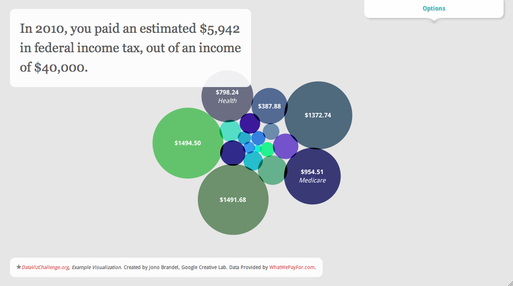
Click the image above to try the interactive version—it lets you drag the bubbles around, change the income level and so on. You can now look at the data in a new way, and it’s a little more fun to explore. Of course, there are lots of ways to visualize the data, and we’re very sure there are many talented designers and developers around the country who can do it even better than we have.
To make that happen, we’ve teamed up with Eyebeam, a not-for-profit art and technology center, to host what we’re calling the Data Viz Challenge. Andrew and Louis have built an API to let anyone access the data, so now you can choose how to display it. Could you create a better animated chart? Something in 3D? An interactive website? A physical display somewhere in the real world? We want you to show everyone how data visualization can be a powerful tool for turning information into understanding.
You can enter the challenge at datavizchallenge.org, where you’ll also find more information about challenge and the data. The challenge starts today and ends March 27, 2011, and is open to the U.S. only. The top visualization, as chosen by a jury, will receive a $5,000 award and a shout-out on the site and this blog. We’ll announce the shortlist on the week of April 11, and the winners on April 18, a.k.a. Tax Day.
If you’re a data viz enthusiast, we hope you’ll take a look at the data and build your own creative visualization. But even if you’re not, hopefully the results will help you appreciate what data visualization can do, and its usefulness in turning raw information—like federal income tax numbers—into something you can explore and understand.
Fortunately, there’s a new online tool to help us find out. Last year, Andrew Johnson and Louis Garcia, two developers from Minneapolis, Minn., created a website called whatwepayfor.com that uses public data to estimate how our tax money is spent. You enter your income and filing status on the site, and it creates a formatted table of numbers showing your contributions to the federal budget—down to the penny:

We’re impressed by what the website uncovers. In 2010, for example, a married couple making $40,000 a year contributed approximately $14.07 to space operations, $6.83 to aviation security and $0.91 to the Peace Corps…and those are just a few of the hundreds of expenditures revealed on the site. As we spent time exploring all of these details, it got us thinking: how we could make the information even more accessible? So we created a simple interactive data visualization:
Click the image above to try the interactive version—it lets you drag the bubbles around, change the income level and so on. You can now look at the data in a new way, and it’s a little more fun to explore. Of course, there are lots of ways to visualize the data, and we’re very sure there are many talented designers and developers around the country who can do it even better than we have.
To make that happen, we’ve teamed up with Eyebeam, a not-for-profit art and technology center, to host what we’re calling the Data Viz Challenge. Andrew and Louis have built an API to let anyone access the data, so now you can choose how to display it. Could you create a better animated chart? Something in 3D? An interactive website? A physical display somewhere in the real world? We want you to show everyone how data visualization can be a powerful tool for turning information into understanding.
You can enter the challenge at datavizchallenge.org, where you’ll also find more information about challenge and the data. The challenge starts today and ends March 27, 2011, and is open to the U.S. only. The top visualization, as chosen by a jury, will receive a $5,000 award and a shout-out on the site and this blog. We’ll announce the shortlist on the week of April 11, and the winners on April 18, a.k.a. Tax Day.
If you’re a data viz enthusiast, we hope you’ll take a look at the data and build your own creative visualization. But even if you’re not, hopefully the results will help you appreciate what data visualization can do, and its usefulness in turning raw information—like federal income tax numbers—into something you can explore and understand.
Следенето във Facebook стана по-лесно с Breakup Notifier
На вниманието на всички, които са проверявали семейното положение и стената на някой приятел във Facebook, към когото все още таят чувства, или пък на новите си избраници: това дебнене става по-лесно благодарение на Breakup Notifier! Това ново приложение, което известява по и-мейл, когато съответната цел смени семейното си положение, даващо възможност да се втурнете в авантюра, докато Вашият избраник е все още уязвим.
По-интересното в случая обаче, е как е хрумнала идеята за това приложение. Дан Льовенхерц, създателя на приложението, си седял един ден, опитвайки се да намери приятел на сестрата на своята годеница. Но когато погледнал профила му във Facebook, открил, че въпросният господин е във връзка. Както някой би направил в подобно затруднение, Дан прекарал 4 часа в програмиране, създавайки услуга, която Ви уведомява всеки път, когато човекът, към когото имате интерес, смени своето семейно положение.
Приложението работи по следния начин - на всеки 10 минути изпраща ping до Facebook, за да провери съответния семеен статус. Това е наистина полезно, когато нямате достъп до избрания/избраната, също така е и дискретно, така че докато не споделите пред някого, че използвате Breakup Notifier, няма да има по-информиран от Вас.
Всичко, което трябва да направите е да се логнете в Breakup Notifier , използвайки Вашия Facebook акаунт, да изберете приятелите, които да следите и дебненето започва. Бързо и лесно.
Льовенхерц е също собственик на сайтовете areweenemiesyet.com , които пък уведомяват всеки път, щом някой Ви премахне от списъка си с приятели. Има информация, че Дан възнамерява да сложи символична цена от 99 цента за първите потребители, а след време цената да скочи до $4,99. Така че, като че ли сега е времето да се регистрирате, докато все още е безплатно.
Got ideas? We're listening.
 In the past several months we’ve added several new features to Google Custom Search – and we have you to thank! More than a year ago, we told you about a new Google Custom Search Product Ideas page, and since then you’ve voted thousands of times on all sorts of great ideas for improving the product. That doesn't even include the stellar suggestions we get on a regular basis in the help forum. In fact, query autocompletion was a help forum suggestion from swoodby that’s now available with just a few clicks in the Control Panel. We’re thrilled that we have this productive feedback loop with you, and want to report back on some of the product iterations we made during the past year.
Wireless data consumption has more than doubled every year, so we’re happy to have added mobile search features to the product. As requested on the Product Ideas page, users can now search on your website using their mobile devices. The default homepage for your custom search engine is now optimized for your on-the-go users. We will continue to optimize Custom Search to meet the needs of a growing mobile user base.
In response to your requests for metadata capabilities, we launched a set of features to support structured custom search. You now have the ability to filter by attributes such as author, define attribute ranges such as dates, and sort by specific attribute values such as ratings. We plan to make these metadata features even easier to use through the Custom Search Element, which generates code that you can copy and paste to easily add Custom Search to any website.
You’ve also made it clear from your feedback that you love customizing your search engine and adding your own flair. So, over time we’ve made it possible for you to tweak the layout of your results, customize your synonyms, control autocompletions, and apply custom styles to your search engine. Now it’s even possible to select a theme for your ads.
What’s the moral of the story here? Your mic is on and we’re listening. Keep the feedback coming in the help forum (the Product Ideas page is closed for now) and we’ll continue working to make Custom Search better. After all, it’s really your product.
76 процента от лондончани против покритие за телефоните си в метрото
Извадка от 1094 лондончани показва, че само 24% искат покритие на своите клетъчни телефони и в Лондонското метро. Останалите 76% са против, сочи проучването, направено от GoodMobilePhones.co.uk.
Това проучване бе провокирано от потвърждението на китайската компания за мрежови технологии Huawei, че ще наддава в борбата за снабдяването на метрото с мобилно покритие навреме за Олимпийските игри през 2012-та.
От хората, обявили се против построяването на мрежата от Huawei, 31% се обосновават, че се страхуват от потенциални крадци и разбойници, докато 16% вярват, че използването на техните телефони в подземната мрежа ще доведе до покачване на месечните им сметки.
Въпреки това обаче, 24% от анкетираните посочват идеята за подземно използване на телефоните си като добра, обосновавайки се, че мобилният достъп ще направи по-лесен достъпа до спешни услуги в съответните ситуации.
Основателят на GoodMobilePhones.co.uk Марк Оуен каза: "Новините за подземна мобилна мрежа със сигурност предизвикват вълнение у хората, но съм изненадан колко много от лондончани са против нея. Очевидно има рискове с повишаването на покритието в метрото, но това са неща, които могат да бъдат преодолени. Съществуването на подземна мобилна мрежа е следващата логична стъпка, вървейки по стъпките на Париж и Хонг Конг, които нямат никакви съществени проблеми" - завърши той.
GetListed Portland
Today, I am presenting at the sixth GetListed.org Local University in Portland, Or. If you are coming PLEASE take a moment to introduce yourself as I would love to meet you.
For those of you that attended the presentation these links will provide background information and details for a pathway to dig deeper into the world of managing your listing on Google Maps. For those of you that are not in attendance, the links provide a good overview of critical base line ideas and tactics that every local campaign should embrace.
Google Maps – Its not your mother’s yellow pages.
Slide 2 - January 2011 Search Engine Market Share
Slide 12/13 - The Importance of Page One Visibility
Slides 16/17 - How the Google Cluster Works
Slide 21- Choosing the Right Category – A Tool
Slide 21 - Writing a Great Business Description
Slide 21 - Google Places Policies: Quality guidelines
Slide 22 - Creating a GeoSitemap – A tool
Slide 28/29 Local Search Ranking Factors – the many variables
Slide 28/29 A brief list of 10 Ranking Factors – somewhat old but still valid and a quick read
Slide 28/29 Thinking about your Business Name in the Internet Era
Slide 30 - Custom Maps – A Goldmine
Slide 30 - User Generated Content – Geo Tagged Photos
Slide 30 - How To Gather Reviews
Slide 30- Where to Gather Reviews
Slide 31- The Importance of Citations
Slide 31 - 20 Citation Sources in the US
Slide 36- A Listing management tool
Related posts:
След няколко седмици Adobe ще пусне Flash за Android OS 3.0
т Adobe Systems заявиха, че през слядващите няколко седмици ще публикуват версия на своя Flash Player с поддръжка на новата операционна система Android Honeycomb 3.0, предназначена за работа на интернет таблети. Според представители на компанията, Honeycomb е първата версия на Android, специално разработена за устройства с по-голям екран от дисплея на смартфон, което обаче поставя към Flash повишени изисквания.
Мат Розен, представител на Adobe, казва, че по оценки на фирмата, през тази година на световния пазар ще се появят около 50 различни модели таблети с поддръжка на Flash, като първият от тях ще бъде Motorola Xoom на цена около 800 долара. В блога на компанията се отбелязва, че до края на тази година Flash ще работи на 132 милиона устройства, които поддържат тази среда.
Преди няколко дни Adobe показа нова версия на Flash за смартфони с поддръжка на технологията Stage Video, създадена с цел намаляване на натоварването върху процесора и икономия на ток от батерията на мобилните устройства. Том Нгуен, мениджър по продуктовата серия Flash, твърди, че Stage Video използва всички възможности за хардуерно ускорение на целия видеопоток.
"Stage Video означава, че Flash Player може да възпроизвежда видео с най-добро добро качество и по-ниска консумация на системни ресурси, което позволява на потребителите да се възползват по-пълно от него и устройството. В памките на нашия вътрешен тест беше констатирано, че натоварването на системите в някои случаи намалява до 34 пъти" - казва Нгуен.
Според него, съвременните компютри, работещи под операционните системи Windows или Mac и имащи инсталиран Flash Player 10.2, HD-видео с резолюция 1080р се възпроизвежда с 15% натоварване на процесора. Ще припомним, че по-рано много разработчици на мобилни платформи, включително Apple, критикуваха Adobe за прекалено активното използване на системни ресурси и високото натоварване на процесора при показване на Flash видео.
Нгуен добави още, че Video Stage може да обработва се справи не само видео, но и различните други компоненти, като например текст, изскачащи елементи, както и елементи за управление на възпроизвежданото видео. Преди поддръжката на всички тях съществуваше само в случаите, когато видеото беше кодирано във формат H.264, а сега системата работи във всички формати.
Motorola Atrix вече може да се купи от AT&T, Amazon и Walmart
Първият Android телефон на Motorola - Atrix, вече може да се купи от AT&T, както и от търговци като Amazon, Walmart и Radioshack.
Цената на телефона е $199,99 ако се закупи от AT&T, но условието е подписване на двугодишен договор. Нещата при Amazon и Radioshack седят малко по-различно - цената там е $149,99, а в Walmart цената от $129,99 е промоционална, но е достъпна само ако активирате своя акаунт преди четвъртък.
Смартфонът Atrix е един от най-мощните на пазара, работещи с операционна система Android 2.2 - той има двуядрен 1GHz процесор Nvidia Tegra, 1GB RAM памет и 960x540 qHD екран. Освен това той е и много гъвкав откъм възможности, защото притежава опцията да се свързва с лаптоп или други мултимедийни устройства, което наистина значително увеличава функционалността му.
Така излизането на телефона на пазара изпревари първоначалната официално обявена дата 1-ви март.
Поредната антитръстова жалба срещу Google
Европейската комисия започна поредното разследване срещу IT магнатите от Google. От ЕС ще трябва да преценят дали компанията е в нарушение с антитръстовите закони и дали поведението й ограничава свободната и лоялна конкуренция.
Жалбата до Европейската комисия е подадена от 1plusV. Това е френска компания, специализираща в областта на търсачките. Според нея и според написаното в оплакването Google постоянно извършва действия, които възпрепятстват по-малките си конкуренти да генерират приходи, тъй като интернет групата злоупотребява с доминиращата си позиция на пазара на търсене.
Всъщност 1plusV е собственик на френската търсачка eJustice.fr. Тя се явява една от подалите жалба срещу Google през ноември миналата година. С още две по-малки и тепърва разрастващи се компании 1plusV обвиняват интернет гигантите в това, че дискриминира в резултатите си при търсене сайтовете на фирми, предлагащи конкурентни на нейните услуги.
Новата антритръстова жалба, подадена до Европейската комисия, посочва и нови нарушения на Google. Те продължават да са си от същото естество – злоупотреба с господстващо положение и поведение, създаващо условия за нелоялна конкуренция. В оплакването се подчертава няколкократно, че Google са изтрили от резултатите си eJustice.fr и 1plusV. Отговорът на IT магнатите съдържаше обяснение, че показването на техните резултати в търсачката се базира на рангова система – тези резултати зависели от значимостта на дадена страница и на нейната популярност сред онлайн аудиторията.
От Google се и оправдаха, че не веднъж са отправяли предложения към стотица сайтове за подпомагането им, за да станат по-известни за потребителите. Интернет гигантите добавиха и, че са наясно с европейските закони срещу нелоялна конкуренция и злоупотребата с господстващо положение. Нещо повече – Google твърдят, че ЕК е наясно с техния бизнес модел – но това не означава, че компанията не би изразила готовност да промени някои от стратегиите си, за да задоволи и законотворците, и потребителите си.
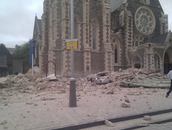
Resources for the latest Christchurch earthquake
It was just last September that we were discussing the earthquake that struck Christchurch, New Zealand, and now they've been hit by another powerful quake.
As you might expect, and as reported by Google Maps Mania, there are already a variety of resources available to assist those in the area.
The easiest is the Google Person Finder for Christchurch, to help track down anyone that has been affected by the earthquake. You can use the site if you're looking for someone, or if you know the condition of someone that others may be looking for. As of now, the site already has nearly 5000 records.
Along those lines, I'm very happy to report that Frank is doing well. Him and Karen were in Christchurch when the quake struck, and while they saw a lot of damage around them, they are unharmed. You can read about it on the Tahina Expedition blog, which includes some photos he has just taken in Christchurch.
Another great resource for the quake is this very useful Ushahidi-powered site, which provides information about hospitals, road conditions, hazard zones and other related information. It's an excellent resource to have available if you're on the ground in the area.
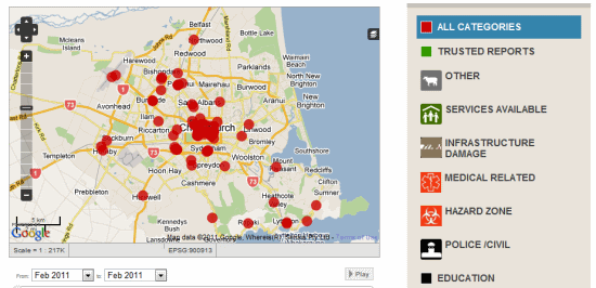
Finally, I encourage you to check out the Christchurch Quake Map, which shows all of the quakes and aftershocks in the area for the past year (nearly 5,000 of them). You can filter the map to show only the 55 quakes that have struck in the past 24 hours.
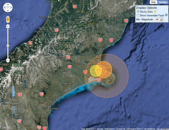
If you're aware of any other great resources, please leave a comment and we'll update this post as needed.
As you might expect, and as reported by Google Maps Mania, there are already a variety of resources available to assist those in the area.
The easiest is the Google Person Finder for Christchurch, to help track down anyone that has been affected by the earthquake. You can use the site if you're looking for someone, or if you know the condition of someone that others may be looking for. As of now, the site already has nearly 5000 records.
Along those lines, I'm very happy to report that Frank is doing well. Him and Karen were in Christchurch when the quake struck, and while they saw a lot of damage around them, they are unharmed. You can read about it on the Tahina Expedition blog, which includes some photos he has just taken in Christchurch.
Another great resource for the quake is this very useful Ushahidi-powered site, which provides information about hospitals, road conditions, hazard zones and other related information. It's an excellent resource to have available if you're on the ground in the area.
Finally, I encourage you to check out the Christchurch Quake Map, which shows all of the quakes and aftershocks in the area for the past year (nearly 5,000 of them). You can filter the map to show only the 55 quakes that have struck in the past 24 hours.
If you're aware of any other great resources, please leave a comment and we'll update this post as needed.
Немско приложение за iPhone показва локации, достъпни за хора в инвалидни колички
Раул Краутхаузен, който е в инвалидна количка от дете, споделя негативно мнение за услугите, които Германия предлага за хората с физически увреждания. Според него услуги, като специалните таксита и доставките на хранителни продукти, нерядко са покровителствени и го изолират още повече.
За това той поема нещата в свои ръце, като създава wheelmap.org – приложение за iPhone и уеб сайт на английски и немски, които позволяват на потребителите да споделят класации и съвети относно достъпността на магазини, барове и други места.
„Искам да бъда подвижен и да не завися от това, кога дадена транспортна фирма ще има време да ме вземе”, споделя Раул. Оказва се, че не само той се чувства по този начин. Сайтът получава 300 нови потребителски рейтинги дневно и към този момент дава информация за около 30 000 локации. Около 80% от коментираните места са в Германия, но базата данни бавно се разраства и към градове като Лондон и Ню Йорк.
„Целта на Wheelmap.org е да помага на хората с физически увреждания да научават за места, които са достъпни за тях”, допълва още създателят на сайта.
Според Краутхаузен успехът на Wheelmap се дължи на достъпността му чрез iPhone апликация, както и на т.нар. „Wiki принцип” – идеята, че всеки може да допринесе за развитието на сайта. Потребителите могат да класират локации без да се регистрират, но трябва да го направят, ако искат да добавят специални коментари.
Видеоклипове със самонараняване – сериозна заплаха
Нова заплаха за здравословното състояние на потребителите се шири сред видеоматериалите на YouTube. Оказа се, че най-голямата страница за споделяне на видеоклипове притежава богато съдържание на снимки и клипове, в които се изобразява, а дори и пропагандира самонараняването. Изследване на видни психолози и социолози стигна до извода, че такива видеоматериали и то публикувани на сайта на YouTube поставят в риск хора с разклатена и слаба психика – най-вече такива, които вече са започнали да се самонараняват или поне имат такова намерение.
Една част от тези видеоклипове показват живи демонстрации на самонараняване – предимно чрез рязане на китки или горните части на краката с бръснарски ножчета и други остри предмети. Другата част от видеоматериалите са само слайдове на изображения с подобно съдържание на фона на потискаща музика, която сама по себе си натрапва депресивни мисли. Под каквато и форма да са създадени клиповете в YouTube, те са прекалено сюреалистични и детайлни. Психолозите са на мнение, че самонараняването като психичен проблем или като симптом на личностното разстройство са особено характерни за подрастващото поколение – т.е., извадката от обществото, която най-често се заседява пред компютъра и сърфира из страници като YouTube най-вече.
Канадският психолог Stephen Lewis публикува няколко статии във връзка с този проблем – самонараняването – и как голяма част от видеоклиповете в YouTube го доразвиват и задълбочават. Ученият открива над 5000 видеоматериала с такава тематика, публикувани на сайта. Сто от тях са гледани приблизително по два милиона пъти и са с по осемдесет коментара.
Stephen Lewis е на мнение, че решението на проблема трябва да е комплекс от мерки, които да бъдат взети на различно ниво. На първо място, от особено значение е ролята на родителите, които знаейки за проблемите на детето си, да следят стриктно за активността му и в реалния живот, и в мрежата. Лекуващите лекари на хора, страдащи от подобни психични проблеми, също трябва да се интересуват от пациентите – как са получили импулсите на желание за самонараняване и дали те не са провокирани реално от някой или нещо в интернет. Stephen Lewis съветва и администраторите на YouTube да вземат скоростни мерки – най-вече за премахване на подобни клипове. Психологът предлага и друг алтернативен вариант със справяне с проблема – ако все пак видеоматериалът със съдържание, подтикващо към самонараняване, остане на сайта, под него да се изпишат номера за гореща връзка или хора, към които нуждаещите се да се обърнат за помощ.
Huawei предлага да изгради мобилна мрежа в лондонското метро
Китайският технологичен гигант Huawei предлага за Олимпийските игри през 2012 година да изгради безплатно мобилна мрежа в лондонското метро на стойност 50 милиона фунта стерлинги (около 80 милиона долара).
Изграждането на мобилна мрежа в лондонското метро се дискутира от много години, но така и не е било реализирано досега поради бюджетни ограничения. Huawei представя предложението като подарък към нацията, която ще приеме Олимпийските игри, от страната-домакин на предишните игри, съобщава вестник "Сънди таймс".
Huawei предлага да инсталира мобилни радиостанции в тавана на тунела на метрото, така че посетителите и пътниците в него да могат да звънят и да приемат обаждания.
Мобилните оператори, включително Vodafone и O2, са се съгласили да покрият разходите по строителните работи, а Huawei се надява в бъдеще да получава средства под формата на такса за обслужване на мрежата.
От Transport for London (TfL) - официалният орган, отговарящ за транспортната система в британската столица, заявиха, че преговорите по покриването на метрото с мобилна мрежа вече са започнали, макар и да не потвърдиха официално участието на Huawei в тях. В изявление на TfL се казва: "Transport for London и кметът на Лондон в момента водят преговори с мобилните оператори и други доставчици относно възможностите за предоставяне на мобилни услуги в метрото".
Въпреки това, членът на британския Парламент от Консервативната партия Патрик Мърсър смята, че да се позволи на китайската фирма да създаде мобилна мрежа може да бъде заплаха за националната сигурност. Причината за това е, че компанията Huawei отдавна е обвинявана във връзки с китайските военни.
GPS устройство ще шпионира нередовните ученици
Американско училище ще прибегне до услугите на Global Positioning System (GPS) технологията, за да следи и обуздае непослушните ученици – най-вече тези, които системно бягат от час и пропускат занятията си. Става въпрос за Anaheim гимназията в щата Калифорния. Училищното настоятелство там започна шестседмична програма, работеща на базата на GPS технологията. Около седем осми от учениците на Anaheim гимназията имат над четири неизвинени отсъствия. Всички тези възпитаници на гимназията, а и бъдещите провинили се в периода на следващите два месеца, ще трябва да вървят навсякъде с GPS устройство, което да следи къде ходят, какво правят и с какво запълват времето си, докато не се учат нови знания в класните стаи.
GPS устройството на нередовните ученици всяка сутрин ще им напомня, че са длъжни да отидат на училище. Нещо повече – когато те не са в сградата на гимназията, а трябва да са там – ще се задейства писукаща аларма, която да изиграе ролята на мъмрещия учител или директор. Програмата бе приета добре както от родителите, така и от учениците.
В същото време следенето на бягащите от час ученици чрез GPS устройства никак не излиза евтино за училищното настоятелство. Шестседмичната програма ще струва на Anaheim гимназията над 18 хиляди щатски долара. За всеки нередовен ученик се отделят по около 400 долара за проследяващо GPS устройство.
На училищното настоятелство бе отправено предложение вместо учениците да носят GPS устройство, такова да им бъде прилепено по начин, по който да не могат лесно да се отърват от него. Учителите обясниха, че подобен метод е недопустим, тъй като в крайна сметка нередовните гимназисти не са престъпници, за да им е необходима някаква гривна за крака или ръката с чип. В случая им е необходима просто малко дисциплина. Най-вероятно шестседмичната програма за контрол на присъствието в Anaheim гимназията ще сплаши учениците и те ще си научат най-накрая урока.
Panoramio Stats: Where are my photos viewed? | Mapsys.info
Panoramio Stats: Where are my photos viewed? | Mapsys.info
Panoramio is a community photo-sharing site for geo-located images. Photos uploaded to Panoramio show up on its website, as well as other places such as Google Earth and Google Maps.
We’re excited to announce that detailed statistics are now available to users directly within their Panoramio account. Think of Panoramio Stats as a photo-specific version of Google Analytics for Panoramio – in other words, a powerful web analytics tool that helps you measure the performance of your photos. With this new feature, you can track the sites from which your photos have been viewed in visually appealing and intuitive reports.
Native Client: Getting ready for takeoff | Mapsys.info
Native Client: Getting ready for takeoff | Mapsys.info
Over the last few months we have been hard at work getting Native Client ready to support the new Pepper plug-in interface. Native Client is an open source technology that allows you to build web applications that seamlessly and safely execute native compiled code inside the browser. Today, we’ve reached an important milestone in our efforts to make Native Client modules as portable and secure as JavaScript, by making available a first release of the revamped Native Client SDK.
Over the last few months we have been hard at work getting Native Client ready to support the new Pepper plug-in interface. Native Client is an open source technology that allows you to build web applications that seamlessly and safely execute native compiled code inside the browser. Today, we’ve reached an important milestone in our efforts to make Native Client modules as portable and secure as JavaScript, by making available a first release of the revamped Native Client SDK.
Resources for the latest Christchurch earthquake
It was just last September that we were discussing the earthquake that struck Christchurch, New Zealand, and now they've been hit by another powerful quake.
As you might expect, and as reported by Google Maps Mania, there are already a variety of resources available to assist those in the area.
The easiest is the Google Person Finder for Christchurch, to help track down anyone that has been affected by the earthquake. You can use the site if you're looking for someone, or if you know the condition of someone that others may be looking for. As of now, the site already has nearly 5000 records.
I'm very happy to report that Frank Taylor is doing well. He and his wife Karen were in downtown Christchurch when the quake struck, and while they saw a lot of damage around them, they were luckily unharmed. You can read about it on the Tahina Expedition blog, which includes some photos he has just taken in Christchurch.

Another great resource for the quake is this very useful Ushahidi-powered site, which provides information about hospitals, road conditions, hazard zones and other related information. It's an excellent resource to have available if you're on the ground in the area.

Finally, I encourage you to check out the Christchurch Quake Map, which shows all of the quakes and aftershocks in the area for the past year (nearly 5,000 of them). You can filter the map to show only the 55 quakes that have struck in the past 24 hours.

If you're aware of any other great resources, please leave a comment and we'll update this post as needed.
As you might expect, and as reported by Google Maps Mania, there are already a variety of resources available to assist those in the area.
The easiest is the Google Person Finder for Christchurch, to help track down anyone that has been affected by the earthquake. You can use the site if you're looking for someone, or if you know the condition of someone that others may be looking for. As of now, the site already has nearly 5000 records.
I'm very happy to report that Frank Taylor is doing well. He and his wife Karen were in downtown Christchurch when the quake struck, and while they saw a lot of damage around them, they were luckily unharmed. You can read about it on the Tahina Expedition blog, which includes some photos he has just taken in Christchurch.
Another great resource for the quake is this very useful Ushahidi-powered site, which provides information about hospitals, road conditions, hazard zones and other related information. It's an excellent resource to have available if you're on the ground in the area.
Finally, I encourage you to check out the Christchurch Quake Map, which shows all of the quakes and aftershocks in the area for the past year (nearly 5,000 of them). You can filter the map to show only the 55 quakes that have struck in the past 24 hours.
If you're aware of any other great resources, please leave a comment and we'll update this post as needed.
Tools to help the armchair archeologist
A few weeks ago, we showed you a recent case of an "armchair archaeologist" who used Google Earth to discover almost 2,000 archaeological sites in Saudi Arabia.
With more and more stories like this popping up in the past few years, GEB reader "Will from the UK" has built a slick tool to help with the process.
In his words:

The resulting spreadsheet is quite impressive, and it is a great way to divide up a large area for more precise searches.
You can download the Excel-based spreadsheet here. The spreadsheet is remarkably powerful, though it has a bit of a learning curve and a few limitations. Fortunately, Will has been generous enough to develop a User Guide (PDF) to help you get started.
With more and more stories like this popping up in the past few years, GEB reader "Will from the UK" has built a slick tool to help with the process.
In his words:
I enjoyed your post about the archaeologist who found interesting artifacts in Saudi Arabia using Google Earth. It got me thinking about how to do a systematic search of an area using GE.
There are no tools in GE that help, other than the usual lines / placemarks. Marking an area out using lines is fairly tedious. A grid is a useful solution. I have seen grid generators online, but they tend to come and go, and you need to be online to use them.
I have created a spreadsheet that generates the KML code for a Latitude / Longitude grid. A grid allows a more systematic search to be conducted and also allows more people to take part in a search - the work can be divided between many volunteer searchers.
The resulting spreadsheet is quite impressive, and it is a great way to divide up a large area for more precise searches.
You can download the Excel-based spreadsheet here. The spreadsheet is remarkably powerful, though it has a bit of a learning curve and a few limitations. Fortunately, Will has been generous enough to develop a User Guide (PDF) to help you get started.
New Google Earth Imagery - February 24
Google has just pushed out some fresh imagery to various parts of the world, with thanks going to sharp-eyed GEB reader 'Andreas' for being the first to point it out to us!

The full extent of the update is still unknown, but as is usually the case, you can use Google Maps to determine for sure whether or not a specific area is fresh. This new imagery isn't in Google Maps yet, so you can compare Earth vs. Maps to see what's new; the fresh imagery is already in Google Earth, but the old imagery is still in Google Maps. If you compare the two side-by-side and they're not identical, that means that you've found a freshly updated area in Google Earth!
[UPDATED -- 24-February, 4:16pm EST]
- Australia: Melbourne -- thanks 'David'
- Bosnia Herzegovina: Various areas -- thanks 'Andreas'
- Croatia: Various Areas -- thanks 'Andreas'
- Germany: Hohenfels, Marl -- thanks 'Andreas'
- Norway: Various areas -- thanks 'Andreas'
- Romania:Various areas -- thanks 'Andreas'
- Sweden: Areas along the western part of the country -- thanks 'John'
- UK: London -- thanks 'Carl'
- United States: Illinois (west central) and Tennessee (southern sections) -- thanks 'KennyB' and 'Wes'
Follow the Mission Blue expedition to Salas y Gomez
While many of us would like to embark on a voyage across the ocean, we can't all be Frank Taylor. Fortunately, Google Earth provides a great way to explore places virtually, such as with the latest installment in the "Mission Blue" series.
Last month, we showed you Mission Blue's tracking of the gulf oil spill recovery effort. This month, they're heading east from Easter Island to the tiny island of Salas y Gomez in an effort to do some research in the largely unexplored waters around the island.

As with the gulf spill mission, they're providing updates in a variety of ways. You can track it by finding the blue ship icon near Easter Island (be sure the "Places" layer is turned on), by downloading this KML file , or you can track them in the Google Earth Gallery using the Google Earth Plug-in.
Salas y Gomez was updated in the most recent imagery update, featuring imagery that is just a few weeks old. It's a bit fuzzy, but it's much better than what they used to have there. To check out the island for yourself, you can fly there using
this KML file.
For more, check out the full entry on the LatLong Blog or read stories from the crew on the Mission Blue News Watch blog.
Last month, we showed you Mission Blue's tracking of the gulf oil spill recovery effort. This month, they're heading east from Easter Island to the tiny island of Salas y Gomez in an effort to do some research in the largely unexplored waters around the island.
As with the gulf spill mission, they're providing updates in a variety of ways. You can track it by finding the blue ship icon near Easter Island (be sure the "Places" layer is turned on), by downloading this KML file
, or you can track them in the Google Earth Gallery using the Google Earth Plug-in.Salas y Gomez was updated in the most recent imagery update, featuring imagery that is just a few weeks old. It's a bit fuzzy, but it's much better than what they used to have there. To check out the island for yourself, you can fly there using
this KML file
.For more, check out the full entry on the LatLong Blog or read stories from the crew on the Mission Blue News Watch blog.
Walk the Red Carpet in Google Earth
Google has made some fun enhancements to the Kodak Theatre in Hollywood, just in time for the Oscar Awards this Sunday. They've added the red carpet, a bunch of paparazzi and other decorations for the awards ceremony.

To see it for yourself, you can fly there using this KML file, or simply watch the video below:
To see it for yourself, you can fly there using this KML file
, or simply watch the video below:Friday, 25 February 2011
Thursday, 24 February 2011
Wednesday, 23 February 2011
Tuesday, 22 February 2011
Sunday, 20 February 2011
Saturday, 19 February 2011
Mapsys info - Geocoding Tools - Geocoding with Google Maps | Mapsys.info
Mapsys info - Geocoding Tools - Geocoding with Google Maps | Mapsys.info
I would like to share with you this simple google geocoding and reverse geocoding tool
Friday, 18 February 2011
Thursday, 10 February 2011
Wednesday, 9 February 2011
Tuesday, 8 February 2011
Friday, 4 February 2011
Tuesday, 1 February 2011
Subscribe to:
Posts (Atom)