Friday 29 April 2011

The Safe FME World Tour

So I’ve spent most of the day in Leeds, attending one of the stops in the Safe FME “World Tour” event. I’m familiar with the name of the FME product – it gets mentioned a lot on the SQL Server MSDN forums as the ETL tool of choice to fix all manner of spatial data loading/conversion problems – but I’ve never actually used it until very recently.

Then, last month, I had some email contact with Don Murray, the president of Safe, and he mentioned he was coming to do two FME events in the UK and would I like to come along. And I’m glad I accepted his offer. The event was very well organised and hosted (courtesy of Dotted Eyes – Safe’s primary UK partner), with some great speakers and a good mix of sessions. The day featured some “Show ‘n’ Tell” slots (as we did at the last Bing Maps UK Usergroup meeting) from the likes of the British Geological Survey and the London 2012 Olympic Games amongst others. I always find it interesting to see what other folks are doing with their spatial data, as well as the problems they’ve faced along the way. There was some nice eye-candy too, primarily courtesy of some Google Earth network links to FME Server and 3D surface models in Adobe Acrobat.

What I found most interesting though is that, despite having never used FME before, it all felt surprisingly familiar. The FME workbench, where you design spatial ETL tasks, will look very familiar to any SQL Server developers who have ever created a SSIS package – you drag various sources, destinations, and transformation elements onto the page, connected into a logical workflow, and you can define environment variables, conditional steps, counters etc. Likewise, the function of the transformers themselves felt very familiar – many of them corresponding directly to OGC methods defined by the geometry and geography datatypes in SQL Server. For example:
  • The Clipper function basically determines the STIntersection() between two geometries.
  • DonutBuilder subtracts one Polygon from another, a la STDifference().
  • The ConxexHullReplacer is STConvexHull().
  • BoundingBoxReplacer? That’s STEnvelope().
  • And CenterOfGravityReplacer is STCentroid().
  • Bufferer is, unsurprisingly, STBuffer().
  • etc.
Some of the slightly more complex transformers have no simple direct equivalent method in SQL Server, but can be created fairly easily in a SQLCLR procedure using the SqlGeometryBuilder or SqlGeographyBuilder classes. LineCloser, for example, turns LineStrings into Polygons by setting the end point equal to the start point. Offsetter adds constant offsets to each coordinate value, rather like the GeometryShifter SqlGeometryBuilder demo by Isaac Kunen.

In fact, Don noted at one point that “FME’s biggest competitor is people writing their own code”. Essentially, all spatial operations (including those performed by FME’s transformers) can be reduced to geometric problems, and solved using mathematics that can be written in almost any programming language – C++, C#, Javascript… but the question is whether you really have the time or inclination to write your own code to import data from OSM, generate a Bing Maps tile layer, drape a raster image over a TIN surface, or triangulate a set of points, when Safe have done that work already?

Thursday 28 April 2011

Closed Contour SPS Maps

Closed Contour SPS Maps

SPS (Sierra Peaks Section)

Closed Contour SPS Maps

Version 2 of the SPS Map by Closed Contours

New Specs:
  • Whiter glaciers/permanent snow with blue contour lines, talked about this in a previous post.
  • Change forest color depending on density (only in Yosemite and Sequoia/King’s Canyon NP so far). I also mentioned this in a previous post.
  • Non-SPS peak names. Discussed earlier as well.
  • Pass names.
  • Trail names, mostly in the NPs.
  • Removed many bogus ‘lakes’ which were actually mis-characterized permanent snow.
  • Added styling for scree, talus, and meadow/marshes.
  • Changed font for SPS peaks to slightly larger, darker, and italic to set them apart from non-SPS peaks.
  • Not a tile change, but added UTM coordinate display in lower right.
The SPS Maps have 248 peaks in the Sierra Nevada range of eastern California (plus Mount Rose in Nevada). The list is maintained by the Sierra Peaks Section, Angeles Chapter, Sierra Club. The map was designed to encompass all of the peaks on the list with a small buffer around them.

Cartography

Using a Transverse Mercator projection with a central meridian of 120° W, origin latitude of 0°, scale factor of 0.9996, WGS84 ellipsoid, and no false easting or northing. This projection was chosen as a compromise between UTM zones 10 and 11 which unfortunately split the Sierra Nevada vertically right through Lake Tahoe. Here’s the proj.4 string for the projection:

+proj=tmerc +lon_0=120w +k=0.9996 +ellps=WGS84
Data

Data sources:
DEMs are from the USGS NED program. (To generate hill-shade and contours.)
Road data are from TIGER.
Hydrology data are from the USGS NHD program.
Trails data are from the NPS and Forest Service.
Land cover data is from NPS and FRAP.
Buildings are from NPS and Mono County.

Google Summer of Code Meetup in Belgium


On the 6th of April, Google Summer of Code veterans Vincent Verhoeven (student for both KDE and Thousand Parsec) and Bram Luyten (mentor for DSpace) gave a presentation about the Google Summer of Code 2011 program to an audience of interested students.

The Google Summer of Code schedule is quite challenging for Belgian students because of the large overlaps between the program and their examinations. However, the presenters made it clear that with careful planning in the application and transparent communication with mentors, successful participation is definitely possible. As an added bonus, if students are accepted in the Google Summer of Code program their participation can be counted as an internship for some of the master's programs at K.U. Leuven.

The presenters were struck by the fact that of the 30+ attendees, none of them had any experience contributing to open source projects. Each of the students used open source software on a daily basis (Firefox, Linux, etc.) so it seemed like a natural progression for this generation of developers to start contributing to the open source community and Google Summer of Code is a great way for that introduction.

Vincent's testimonial made it clear that participating in the Google Summer of Code can be just the start of a series of interesting experiences. Following up on his participation in the Google Summer of Code, Vincent and his buddies from the Thousand Parsac held a codesprint together at the GooglePlex. It's more than bits & bytes alone, it's about building relationships and friendships that last far beyond the span of one summer.

Wednesday 27 April 2011

Street View: Rome

AFAIK I was the first blogger to spot that the new GEarth tours in GE6 supported streetview. I still think this a great bit of functionality and I'm surprised I haven't seen it popping up more. Today I came across yesterday's blog post by Google about how their streetview trike has been capturing imagery of historic European sites (what a cool job that trike operator must have), really clever use of the technology but I was interested in the way they presented the streeview examples: They linked out to GMaps instances of streetview from within the blog, three examples are shown here:

Colosseum

Imperial Forum


View Larger Map


Palantine Hill


It works and is impressive but this form of presentation is clunky if you wanted to see the relationship between sites in which case a GEarth tour becomes the media to choose. As an experiment I've produced these three sites in a GEarth tour, it's a bit rough but I think you can see my point about how this is a better way if the geographic relationship of the three sites is important.
to play in GEarth itself Rome Street View tour
Note I used the wrong forum site.
Good Design Points:
  • You'll note that by use of annotations for Rome, and a 'reference' square I give a sense of location and scale to the viewer.
  • Use of the square allows people to memorise the locations of the three sites as it acts as a strong landmark.
  • I return to high views between sites as this allows people to follow where they're being flown to.
  • I also customised the Colosseum views and tour path (by choosing a different high view) as in its original format the tour flew through the Colosseum walls - distracting for the viewer.
  • I make explicit remarks about how the user can pause the movie to look around and also about how fast the imagery is likely to be downloading. The former is necessary to encourage active use of a tour, most people will hit play and sit back if you don't actively suggest they could do something different. The comment about imagery download will help those on slow connections who may be thinking 'its not working' as all they can see is a pixelated sludge on screen.
Technical Points:
In KML you can control turning on and off streetview, the sunlight slider and historical imagery. It would be useful to be able to do the same for 3D buildings and roads. However, by using the Tour gadget to produce GEarth in a browser (as I did) you can control these layers without needing to code anything.

Monday 25 April 2011

The Bing Read Write World

During his session yesterday at the Where 2.0 conference, Blaise Aguera y Arcas showed the first public demo of where Microsoft are going in the mapping space, monikered (slightly oddly, I find) the Read/ Write world. Described as “an indexing, unification, and connection of the world’s geo-linked media”, it links together elements of Bing Maps, Photosynth, Streetside, Azure, Deep zoom and others into a common framework, with potentially very interesting consequences. You can read more, and see some demonstration applications of the technology at http://readwriteworld.cloudapp.net/ and be sure to check out the following video

It’s obviously very early days, but some of my initial thoughts are as follows:

Finally, some cohesion!

Internally, the MS Photosynth team has been part of the Bing Maps team for several years, but with not much obvious link between the two technologies (other than a fairly trivial way of linking the location of photosynths to a map). More recently, the Bing Maps team became part of the Bing Mobile team. Again, other than the fact that Bing Maps was a component of the WP7 OS, there wasn’t much obvious reason why…

…finally, we’re now starting to see publicly some of the reasoning behind these decisions, and the strategic direction that MS is taking to try to integrate these technologies. For an example, check out the section of the video above, from about 00:45 to 01:30. You’ll see a (3D) Bing Maps street view, with overlaid thumbnails from streetside (car) imagery. This then changes to a horizontal pan along the street images (streetslide), before cutting to a video link entering into the shop. These video transitions link two photo panoramas shot inside the building, which incidentally, could have been recorded by almost anyone using the new iPhone photosynth app….

image

So, that’s Bing Mobile, photosynth, and maps working together for the first time in an application…

Licensing

It’s interesting that, even though this technology has only just been publicly previewed for the first time and is far away from being production-ready, Microsoft have already published an initial explanation of the licensing rights involved in the project. This is obviously something they want to make sure they get right.

Another interesting thing to note is that Microsoft have publicly stated a strong support for the Creative Commons licences throughout the project, with content creators of photos, videos, or panoramas used in Read-Write world retaining “complete control over whether others, including Microsoft, can display it, mash it up, or otherwise present it.”.

I wonder if this is any way a response to some of the recent criticism levelled at the Google MapMaker product (also demo’ed at Where 2.0), which encourages “citizen cartographers” to add their own data to Google Maps but, in doing so, relinquish their rights to that data to Google. (Compare this to Open Street Maps, which has been enabling citizen cartography for many years and uses the Creative Commons ShareAlike 2.0 licence, which allows anyone to use OSM data so long as it is credited appropriately).

There’s already announcements that Bing will be working with 360 Cities to use (and re-use) CC panoramas, as well as CC images through Flickr.

Technical

There are a few demo apps showing examples of web services based on the technology at http://readwriteworld.cloudapp.net/, and there’s also a brief description of the technical spec of the new RML (Reality Markup Language) used to bind the whole lot together. However, at this stage, the demos are only based on a very limited set of data. I’ll certainly be going back to play with these when there’ a bit more data available (MS – how about adding Flickr photos from Norwich rather than base all your demos on Seattle? We have beautiful buildings here! Two cathedrals, a castle, the UK’s largest permanent outdoor market, a pub established in 1249AD…)

Google Expands Offers with Groupon Like Features


Yipit reported yesterday that Google is rolling out an expansion of their Offers program with Groupon like features in the test markets of NY, San Francisco, Oakland and Portland.  Users may sign up Google.com/offers and if you want to be notified of future launches you can leave your email with Google on this form. When you do sign up in one of the targeted cities you receive a email that notes:

Once Google Offers is available in NYC Downtown we’ll send you regular emails letting you in on amazing offers in your area.

The rollout of the Groupon Like Offers Beta, first reported as in development in January, allows user to subscribe to receive email notices to “Get 50% off or more at places you’ll love”. Yipit notes that Google Offers seems to be taking a very similar approach to existing daily deal sites:
  • 50% off or more. Google states that they “partner with some of the best local businesses in your area to bring you great deals at 50% off or more.” The lower bound of 50% off is one of the key underpinnings of Groupon and LivingSocial’s offerings. Google clearly wants its users to perceive these offers very differently from regular coupons.
  • Email distribution. Google will be distributing these offers via email. Google states that they’ll “send you regular emails letting you in on amazing offers in your area.”
  • Opt-in. Google is not auto-subscribing their users to this program. They are asking user to sign-up for Google Offers via the Google Offers landing page.
Offers, Google’s rebranded Coupon product, has been seeing a slow but steady emergence from the dark shadows of neglect. This new beta test comes on the heels of their nationwide expansion of the their Check-in Offers test in Latitude.

Exactly who and how companies participate in the latter two is a bit of a mystery. After the Check-in expansion was announced I emailed Google the following to see if they were willing to share any additional information:

Can you give me any more details about  rollout of the Latitude incentivized upgrade offers? Free or paid? Plan for wider access? Success in Austin?

Google’s response:

I just heard back from my colleague who works on Latitude, and she says that all the info we can share about check-in offers can be found on our recent blog post here: http://google-latlong.blogspot.com/2011/04/check-in-gain-status-and-unlock-offers.html

Friday 22 April 2011

Map of Oil Production, 1960-2010

Oil Through the Ages (screenshot)

An interactive map showing oil production by country from 1960 to 2010. Flash required.

Introducing ProtoRPC for writing App Engine Web Services in Python

Here on the App Engine team, we’re always looking for new ways to make it easier for developers to build applications and services. Today, I’m happy to introduce ProtoRPC, a new tool for creating simple Python services, which requires minimal set up and configuration to create new services.

What can you use ProtoRPC web-services for? Most web applications have the need to send and receive data between different components and/or applications. Typically, developers come up with ad-hoc ways of doing this as quickly as possible. As the application grows larger and the need to share information across components grows, it becomes more difficult to manage. URL end-points are defined and appear inconsistent from one another and a lot of boiler plate code is added checking parameters. This quickly becomes a maintenance nightmare and is a problem that ProtoRPC is built to solve.

ProtoRPC makes it easy to write consistent, reliable web interfaces that can be used, for example, to do the following:
  • Create AJAX URL end-points for use by dynamic web pages and forms.
  • Provide simple and understandable server-to-server communications.
  • Become a back-end for command-line tools or other non-web based clients.
Using ProtoRPC, you can define structured web-services right in the application’s Python code without having to first learn and write a new interface definition language such as Thrift and Protocol Buffers, however still retain the same powerful features such as interface introspection and automatic client generation.

The way to go about defining a web service should be familiar to you if you already have experience working with App Engine db.Models and the webapp framework. The data sent between client and web service are defined in a similar way as Datastore models. The services classes that handle requests are defined similarly to webapps RequestHandler classes. Let’s take a look at a simple example from the ProtoRPC getting started guide. This simple web service says hello to its client:
class HelloRequest(messages.Message):
    my_name = messages.StringField(1, required=True)

class HelloResponse(messages.Message):
    hello = messages.StringField(1, required=True)

class HelloService(remote.Service):

    @remote.method(HelloRequest, HelloResponse)
    def hello(self, request):
        return HelloResponse(hello='Hello there, %s!' % request.my_name)
If this web services was used as the URL end-point for an AJAX based form, Javascript to communicate with the service might look like this:
$.ajax({url: ‘/helloservice.hello’,
    type: 'POST',
    contentType: 'application/json',
    data: ‘{ my_name: Bob }’,
    dataType: 'json',
    success: function(response) {
        // The response is { hello: “Hello there, Bob!” }
            alert(response.hello);
        }
    });
As you can see from the example, ProtoRPC can speak JSON right out of the box. In addition, it is compatible with the protocol buffer binary format and can therefore communicate with clients and servers written using traditionally compiled .proto files.

Right now, ProtoRPC is available as an separate project that can be downloaded here. It’s still considered experimental and may change in substantial ways before being integrated in to the SDK. But even though it’s in preview, it already has a number of useful features, such as a remote service discovery mechanism and a forms interface for easy testing. At the moment, ProtoRPC is only available in Python. As always, we plan to offer it for Java developers in the near future.

Check out the getting started guide for a more complete overview to try out writing a few services of your own!

The Logic Behind the Demise of Google Tags

When a company like Google discontinues a product like Tags there is almost always more than one reason.

Google’s publicly stated reason that they need to focus their efforts on which technologies they expect will yield the most benefit to users and businesses is very plausible.

I think that the statement is accurate as far as it goes.

At best Tags offered little benefit to businesses that were using them. While it allowed for a listing to be visually highlighted and its difficult to value the benefit of that in terms of additional clicks or calls, the product itself generated a very low click volume. There was little accountability nor possibility for accountability of those actions either.

In accounts that I examined, Tags generated between 1.5% and 4% of the total actions reported in the dashboard compared to all of Google’s reported actions. Once Google stopped allowing a Tag to be directed to a website and those Tag actions were directed inward on Google towards a photo or the Place page, a Tag became even less valuable (and less trackable) for a merchant. The change to blended results further decreased the value of Tags in the Places world. At least the other, free actions like driving directions or clicks to your website in Places offer mostly direct and quantifiable value.

The logic of whether to keep a given product in the mix needs to address not only individual merchant needs but Google’s corporate needs as well. You also have to remember, Google is an large stock held company that trades on the public capital markets.

To keep capital flowing, companies like Google need to show regular and steady increases in their income. Google has generated average revenue gains of over $4.5 billion a year for the past 4 years. If you discount 2008 as a recession year then they increased revenues by an average of $5.3 billion a year.

Google needs that sort of growth and more every year to be a contender in the capital markets. Growth of their traditional ad products has slowed as a % of sales. Everyone, including Google, is looking to Local for the next ad growth market. Some companies, like LivingSocial seem to have found a way to access local ad revenue and are already on track to reach a $1 billion of revenue for 2011.

A fixed price product like Tags puts a very real cap on total potential revenue and growth that can ever approach those sorts of numbers.

There are 16 million or so businesses in the US. Even if everyone one of those ponied up for Tags it would generate only $5 billion or so a year. With a self serve product it is estimated that the maximum uptake is about 25% of the potential market. In Google’s case, because of the steep drop in benefit once a Tag no longer shows on the main SERPS, the actual market is likely to be significantly less than that. Thus, even over time, it is unlikely to be able to contribute significant annual growth to Google’s revenue stream. At least not at the level they need.

Income though is only part of the equation. Costs are the other side. And the Local market requires hand holding. Unlike the early adopters of Adwords that could survive with little human contact, the new markets Google is going after minimally need a voice on the other end of the phone. As Groupon, Yelp and LivingSocial have demonstrated, sales into local markets do best with a high touch. Google, at least initially, is going for a light touch with phone support. But even one call from a Tags account into the support line a month would likely eat up the total monthly income. Given the current number of problems with Places, Tags was destined to be a loser.

Google, while still struggling in the local space, has developed two products in Boost and Adwords with local extensions, that have higher upsides and because they function independently of Places fewer problems. Google is obviously searching for a growth market like daily deals but has yet to succeed. You noticed that in the current corporate realignment, they put someone at the head of Local, Jeff Huber, with lots of Adwords and commerce background not lots of local background.

Whether Google is done “clearing the decks” is not yet clear. What their next income move in local will be is unclear. In abandoing Tags,  Google is essentially abandoning the hundred million dollar a year market in search of the multi billion dollar a year market. When Jeff Huber says to provide him with “any suggestions you have on new or different (preferably innovative) things we should be doing” you can be sure that the subtext to that statement is income generating innovative things.

Google Releases Map Maker in the US

It wasn’t clear why Google was deprecating MyMaps over the past several months; removing the ability to search them from Maps in January and removing them from Places last month. Now we know. It appears that MyMaps is being deprecated in the US in favor of Google’s much more robust community map making tool Map Maker.

First released in August of 2008 as a way to engage the public in the creation of maps in the 3rd world, it went mainstream in February of 2009 when Google integrated ugc from the Map Maker community into the Google Maps in 16 countries. According to Google “Using Map Maker, people have built out and edited the maps for 183 countries and regions around the world, and now, due to the contributions of citizen cartographers, 30 percent of people have detailed online maps of the places they live”. Kenya has been a poster child of this effort with a large swatch of the country having been mapped via citizen generated content. Google has even sponsored a Ladies Mapping Party there to increase awareness.

Unlike MyMaps which was essentially unregulated and abused in hopes of increasing local ranking,  each Map Maker user contributions and edits will be reviewed. “After approval, the edits will appear in Google Maps within minutes—dramatically speeding up the time it takes for online maps to reflect the often-changing physical world.” The community design of the system allows for peer to peer as well as moderator inputs on these edits.  There also appears to be a trust ranking system that assigns increasing trust to editors who have more experience and a good track record.

Any such system may have users who attempt to abuse it. Hopefully the system of double checks in Map Maker will discourage abuses and will lead to an increase in Map quality.

Google’s ability to keep up with user generated edits seems strained and hopefully this will allow for accuracy  and speedy updates in out of the way places that otherwise seem to suffer the most in the new world of digital geography.

To learn more about Map Maker for the United States visit Google’s training and Help files.

Related posts:
  1. Google Maps: UGC Maps from Map Maker go Mainstream
  2. Will MapMaker + Steetview Replace TeleAtlas?
  3. Google Maps: New User Content Tab

Thursday 21 April 2011

Nuclear Reactors in Google Earth

Over the years, Declan Butler has built some pretty good tools for Google Earth, including things such as the Avian Flu Outbreak Map and the Global Hunger Map.

Now he's created a map 
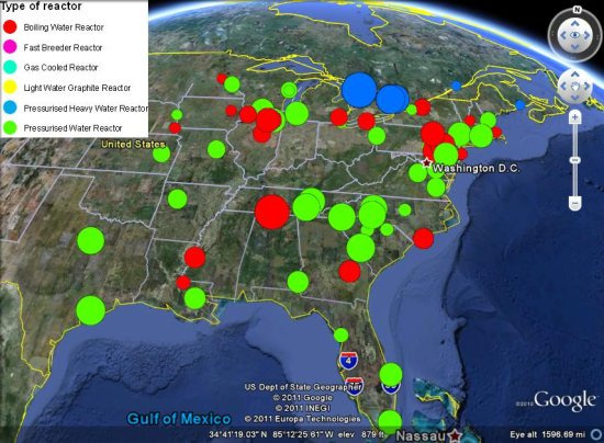
that shows all of the nuclear reactors on earth, color-coded by size and type.
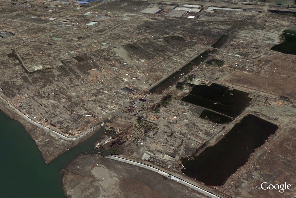
nuclear-plants.jpg

The map has a ton of information, but some of the images don't load correct in the plug-in version linked above. To best use the map, download this KMZ file and load it up in Google Earth.

For more, check out his full post with more info about the map and data, or check out our post from yesterday that shows you how to see day-by-day imagery of the Fukushima plant after the earthquake struck

Sunday 17 April 2011

Google Discontinues Tags

Google Local is shedding products & names almost as fast they are making them these days…they just announced the end of Tags on the Lat Long Blog. I guess I didn’t realize that it was still a trial and was under the impression that it was a real product. Silly me. From their blog:

Since that experiment began, tens of thousands of businesses have used Tags to help potential customers make easier, more informed decisions when searching. Throughout this period, we monitored Tags closely to learn more about our users’ business needs and how they used the product.

We’ve made a decision to shift our efforts toward other present and future product offerings for local businesses, and will be discontinuing this trial. To that end, we’ve now halted new signups and will be working with existing participating businesses over the coming weeks to help them meet their marketing needs with other Google products where possible.

We’ve learned a lot from our Tags trial and will take that knowledge into account as we continue to find the best ways to serve users and local businesses alike. Lastly, we want to thank all of the businesses that were part of our Tags trial, and we hope we can meet their advertising needs with one of our existing products.

I just got off the phone with Jim Prosser, Manager, Global Communications & Public Affairs and he noted that it “makes more sense to focus on other feature opportunities of more value” to the SMB. Google will be working with existing customers to migrate them to a product that better meets their advertising needs.

An email will be going out directly to current Tag advertisers shortly that will describe the alternatives available with Boost and AdWords. For the remainder of this month, Tags will be free and will show thru the end of the month. User of Tags will also be assisted to help them get any data they may want or need before the information is removed from the Dashboard.

Related posts:
  1. Google Tags now Available in 29 States and the District of Columbia
  2. Google Places Forum Adds Tags Discussion Area
  3. Google Begins Nationwide Rollout of Tags and Adds New Features

The New & Hot Garmin StreetPilot for iPhone!

The New & Hot Garmin StreetPilot for iPhone!
Intel Bag http://ping.fm/YasR1
Seals on Being Tenacious http://ping.fm/sxtbB
Google Maps of the Egyptian Protests http://ping.fm/JpAWY
The Art of Maps:Johann Baptiste Homann [California as an Island] http://ping.fm/gzG3G
The Art of Maps: Map of Asia from Atlas sive Cosmographicae by Gerardus Mercator (1595) http://ping.fm/MXwB6
Twitter Real Time Srtreamer http://ping.fm/1M1Sq
Google Maps mashups http://ping.fm/atxAd
Simian: Mac OS X package deployment via App Engine http://ping.fm/1rovp
Google Tool Sends Alert When Satellite Imagery Is Updated http://ping.fm/SgytM
Drive from Colchester to Leicestershire with Front/Rear Camera + Google Earth Overlay http://ping.fm/XdImV
L’Aquila being rebuilt in 3D http://ping.fm/PkOxX
Funny Pictures http://ping.fm/d44eH
The Art Of Maps: The Art of maps: John Speed: Asia with the Islands adioyning described, the atire of the people, & Townes of importance, all of them newly augmented . . . 1626 http://ping.fm/bdZCg
Funny Pictures: Soviet Lada Tunning http://ping.fm/K1mjy
Funny Pictures: Lose your truck http://ping.fm/q6Rg3
Funny Pictures: Strange Kiss http://ping.fm/xfRAx
ESRI ArcGIS 10: ArcGIS Server 10 capabilities http://ping.fm/s7UF3
Sign up for imagery update alert http://ping.fm/YFMjl
Mining for gold with MineCache http://ping.fm/fQrgn
Google Rolls Out Boost Nationwide http://ping.fm/kSTxM
How did Belgrade get such great 3D models? http://ping.fm/hiJ7C
Imagery Update – Week of January 31 http://ping.fm/46qqf
Cancel or Rebook Your Flight for Free While the Massive Midwest Storm Looms http://ping.fm/W7oZw
This Is the Apocalyptic Storm Hitting the US Right Now http://ping.fm/DQJqf
Tips for creating a free business listing in Google Places: Adding useful descriptions and relevant categories http://ping.fm/l02UE
Coming together to model The Hague http://ping.fm/XPHCW
YouTube Captions Uploader Web App http://ping.fm/r3ZzL
Google Earth and Google Maps the wildlife and polar bear http://ping.fm/isg4X
Put Facebook Friends on a Map with Bing – Tekzilla Daily Tip http://ping.fm/R18S9

Twitter Real Time Srtreamer

Twitter Real Time Srtreamer http://ping.fm/7PDf1
Android Developer Challenge, Sub-Saharan Africa! http://ping.fm/v6ORr
Android Market: New Carrier Billing Options http://ping.fm/0kRbr
Taking Chrome to Lite speeds http://ping.fm/ZCNQF
OpenWhatEverMap http://ping.fm/IpFZE
Sessions updated for Google I/O 2011! http://ping.fm/jVTpc
Geocoding Tool http://ping.fm/LbbbY
Twitter Real Time Srtreamer http://ping.fm/diRNV
Satellites around the earth http://ping.fm/VBEHY
Street View takes you inside museums around the world http://ping.fm/wKpsV
Kite Photos of Tikehau Island Now in Google Earth http://ping.fm/GhCl3
Julia meets HTML 5 http://ping.fm/uD6bU
When Google Places Doesn’t Work, It Really Doesn’t Work http://ping.fm/KR3Is
Travel inside of Art Galleries with Street View http://ping.fm/6xKXm
Google Map mashup service linknow friends http://ping.fm/wKBfe
Beauty On the Outside, High Replication on the Inside http://ping.fm/Z1RHm
Check in with Google Latitude http://ping.fm/KnI6u
Google Pushing HotPot to the Big Leagues http://ping.fm/7d9vF
Cycling the Alps adds games, tours and much more http://ping.fm/hUaTJ
Imagery Update: Cowboys Stadium Gets Fresh Bird’s-eye & Aerial Imagery http://ping.fm/zLsSL
Sessions updated for Google I/O 2011! - This post is by Monica Tran. Monica comes to Google by way of the Developer ... http://ow.ly/1cdCAE

Saturday 16 April 2011

Introducing Renderscript http://ping.fm/Tr0pi
Local Search Tools For the SMB and Professional http://ping.fm/LSAju
Where Is A Business Address That is Hidden Not Really Hidden? Google Places http://ping.fm/Z5iTd
Some amazing rides in Street View http://ping.fm/8NOX0
New in Building Maker: See what’s already modeled http://ping.fm/Zxz52
Microsoft ICE (Image Composite Editor), integrating with Photosynth and Bing Maps http://ping.fm/OWgdj
Real-World Cellphone Signal Strength http://ping.fm/l82uu
Google Places Quality Guideline Minor Update http://ping.fm/FY8BK
Yahoo! India Maps http://ping.fm/sHjq1
Azure SQL 2008 – Bing Maps – Near Route Demo http://ping.fm/C1zup
Google Testing New SSSerps? http://ping.fm/Q8Ywm
MapInfo Blues Commercial - Here's a little commercial I did for MapInfo Corporation. It's called the "MapInfo Blues"... http://ow.ly/1ccPpA
New SketchUp books for interior designers http://ping.fm/wJAif
Bing Maps Adds Malls http://ping.fm/1Bhsp
Route Savvy App – Bing Maps http://ping.fm/2x78l
Greg’s Cable Map http://ping.fm/eekSn
Car Pool Google Maps Mashup http://ping.fm/cPA9w
Draggable Routes Demo – Bing Maps API – Windows Azure http://ping.fm/cH04l
New Google Earth Imagery http://ping.fm/TKZ48
Draggable Routes Demo – Bing Maps API – Windows Azure http://ping.fm/mmCWX
Report a Problem with Google Maps http://ping.fm/AIKO9
ESRI ArcGIS 10 Online Capabilities Part 2 of 2 http://ping.fm/sGIGO
Bing Maps – Piracy Watch http://ping.fm/uOMhT
Bing engages open maps community http://ping.fm/nV5ij
Leadwerks Engine for Architectural Visualisation http://ping.fm/UxUTo
The Bing Maps Education App http://ping.fm/XyUms

Friday 15 April 2011

Updated Google Interface Rolling Out? http://ping.fm/Lrco2
Act Locally with New Imagery & Maps in Sudan http://ping.fm/HVReJ
Battle of Britain – Bing Maps http://ping.fm/l2b6u
Seattle.gov ‘My Neighborhood’ – Bing Maps http://ping.fm/bayeQ
MapInfo On demand / SaaS for MapInfo Pro Users = mapworkspace.com http://ping.fm/Ke4NR
File Geodatabase API Is Now Available on Linux http://ping.fm/90No6
New Free-Busy feed for the Google Calendar API http://ping.fm/MJZdK
Using My Maps for your summer sublet http://ping.fm/c3ucQ
MapInfo Blues Commercial http://ping.fm/qBRLl
Bing Maps in Hotmail http://ping.fm/xdFcl
Another disaster looming for Oz http://ping.fm/M6lb9
Perth bushfires http://ping.fm/ko7Xo
National Address Gazetteer (GeoPlace) http://ping.fm/UIUEf
Google Plugin for Eclipse and GWT 2.2 now available http://ping.fm/8wcbI
Google Maps API and Yelp http://ping.fm/AqjOa
Visualize your own data in the Google Public Data Explorer http://ping.fm/i7mLn
Google Place/Tags Support Calls Me Back http://ping.fm/IzLU5
Mapping favourite romantic movie scenes http://ping.fm/Wm5tl
Updates to the Google Reader app for Android http://ping.fm/op0L8
ESRI ArcGIS 10 Quick Glimpse and Overview Part 1 of 2 http://ping.fm/aSs5B
Mapinfo vers Google Earth http://ping.fm/XaG6f
Google I/O – Keynote Day 1 (full) http://ping.fm/Lh2ex
5 tips for using Blogger on your Android phone http://ping.fm/bT07Q
An update to Google Social Search http://ping.fm/ifDp7
The Art of Maps: PIRI REIS MAP http://ping.fm/UteyO
Japan Earthquake and Nuclear Threat http://ping.fm/hCGqA
Japan Earthquake Online http://ping.fm/c1amA
War in Libya http://ping.fm/JnajF
Bulgaria-Sightseeing-Map-Locations.jpg (2702×1787) http://ow.ly/4Bdez
War in Libya http://ping.fm/efbzM
Google Maps Realtime radiation Japan Map | Mapsys.info http://ow.ly/4Bd9Z
Geoportal Server http://ping.fm/SR9FA
Free data, maps – unique insights http://ping.fm/hDl3r
London Bus Flows: An URBAGRAM Animation http://ping.fm/W4HKk
Free data, maps – unique insights - I am launching today another service which is a part of a bigger development pro... http://ow.ly/1cciMj
5 Tips for Responding (or Not) to “Fake” Reviews http://ping.fm/7a5Zh
Maps APIs over SSL now available to all http://ping.fm/gPq6i
How Google Earth displays dates on their imagery http://ping.fm/HwgXv
Dev Tip of the Week: Using Bing Maps with SQL Server spatial http://ping.fm/c4NrX
Dev Tip of the Week: How to search by driving time with AJAX v7, REST, and Spatial Data Services http://ping.fm/BaqbY
Reverse Geocode Template for Microsoft Excel http://ping.fm/YqGcn
Quantum GIS: Geocoding & Reverse Geocoding plus Google Maps (and OpenStreetMap and Yahoo) overlays http://ping.fm/esDgx
Google Chrome OS Providing Click To Call Functionality http://ping.fm/Y5Pu2
W3C Geolocation API, Internet Explorer 9, and Bing Maps http://ping.fm/rIGOl
Google Maps: A new angle on the world with 45° imagery http://ping.fm/tuVZV
Dive into the ocean with Google Earth for Android http://ping.fm/zFVJ3
Google I/O 2010 – Tips and tricks for Google Earth API and KML http://ping.fm/j64Zq
Google Maps 5.0 for Android http://ping.fm/Tlhe3
Google Maps Adds A Fuel Cost Calculator http://ping.fm/lgoWN
Google maps: New Street View imagery of historic sites in Italy and France http://ping.fm/Ant5s
Bing Maps V7 – Modular design and Client Side Clustering http://ping.fm/blzhl
KML and Google Earth API: Recent updates and resources http://ping.fm/97vO4
Twitter Real Time Srtreamer http://ping.fm/pU7Rs
Geocoding Tool http://ping.fm/xBOCU
Bing Maps Streetside http://ping.fm/IRAiX
Google Maps: New 45° imagery for fun in the sun http://ping.fm/O3Rg3
Google Earth: Plug-in running slow? Here’s a few tips http://ping.fm/q3nkN
Five Universities with great maps http://ping.fm/thP0e
Google Maps: Helping you find the right route http://ping.fm/1SFtW
Geoportal Server http://ping.fm/W0ggr
Geoportal Server - Yes, Geoportal Server has been available on SourceForge since late October. Licensing, source cod... http://ow.ly/1cc5AA
Five Universities with great maps - Over the years we've shown you a variety of Universities around the world that a... http://ow.ly/1cbPPR

Thursday 14 April 2011

Launching Google Game Developer Central http://ping.fm/7OEjA
Bing Maps V7 – Modular design and Client Side Clustering http://ping.fm/pQLpm
Import Mapinfo into Micromine http://ping.fm/e9MIQ
Google Earth on the Motorola Xoom http://ping.fm/XS2Nq
From Bermuda to the Bahamas with the Sargasso Sea Expedition http://ping.fm/MxsXn
Pedaling to new places with Street View http://ping.fm/taJCa
Geospatial Revolution: Episode Three Released http://ping.fm/MuCgw
Libya Crisis Map http://ping.fm/xgZHa
Google Maps API and New York City http://ping.fm/eoQjC
Ski the slopes in Google Earth http://ping.fm/zWNAe
Google Maps Navigation will now automatically route you around traffic | Mapsys.info http://ping.fm/i1le1
Mapsys info - mapping and geospatial news - Part 69 http://ping.fm/z0uBt
ESRI ArcGIS 10: Setting Up ArcGIS Server 10 in the Amazon Cloud http://ping.fm/nKQCI
New SketchUp 8 books from Bonnie Roskes http://ping.fm/5v9rX
Japan Earthquake Online http://ping.fm/pDy1v
Google Developer Day US -Making Maps Mashups Discoverable http://ping.fm/rgWsn
New York: Pinball Skyline http://ping.fm/4kxZp
W3C Geolocation API, Internet Explorer 9, and Bing Maps http://ping.fm/dVWhg
Shaker Village in Google Earth http://ping.fm/1GBaD
Big Data – The Strata Review from JISC http://ping.fm/Z4zQL
Japan Earthquake and Nuclear Threat http://ping.fm/nnRGT
Explore events with Localstreamer.com http://ping.fm/IBQYj

Wednesday 13 April 2011

Instant Previews now available on mobile http://ping.fm/JJzHT
Join the League of Extraordinary H4ckers at SXSW! http://ping.fm/gcDUJ
Angry Birds Go Bing: Map Search http://ping.fm/zQr7f
Last Call for Google I/O http://ping.fm/Sr6u8
Googlers are Everywhere http://ping.fm/MHo87
Styling and skinning your apps with TravelTripper http://ping.fm/JQc3K
Bing Maps Tip of the Week: Shift-click and Right click http://ping.fm/7Rz2n
Mappa Mercia Demonstrating the Power of Open Street Maps http://ping.fm/CE9kN
Mini-Newsletter From Your Google Chrome Security Team http://ping.fm/6hPko
5 Tips for Responding (or Not) to “Fake” Reviews http://ping.fm/lYk72
A Big Overhaul is Getting Google’s Street View Website http://ping.fm/9eQ15
The Weeks Media Update http://ping.fm/0zJyB
Round-up of all imagery and resources available for Japan Earthquake http://ping.fm/paN20
New Street View imagery in Japan http://ping.fm/40QzI
New Google Earth imagery of post-earthquake Japan http://ping.fm/vQFSR
Google Places Dashboard: Widespread Reports of System Error http://ping.fm/27Y9h
Google: Celebrating 1 year of Integrated Goodness http://ping.fm/rG04g
Open delimited text file in mapinfo http://ping.fm/ZhGbn
Video Demonstration: Illinois Public Health Map http://ping.fm/D4RPH
Ordnance Survey Open Data into SQL Server 2008 http://ping.fm/zqSsM
Google Earth resources for the Japanese Earthquake http://ping.fm/5teF8
Google Places Dashboard – There’s Good News and There’s Bad News http://ping.fm/NDCCY
Japan: Visit the Hiroshima Peace Memorial in Street View http://ping.fm/ydtEa
Unlock offers, check in, and gain status with Google Latitude in Austin http://ping.fm/HjBPA
Engineering a network in Haiti with Google Earth http://ping.fm/97oyy
Reverse Geocode Template for Microsoft Excel http://ping.fm/fwmji
Google Earth and London in 3D http://ping.fm/OKt52
Google Earth: Post-earthquake images of Japan http://ping.fm/EZDm2
Google Maps Realtime radiation Japan Map http://ping.fm/3mqjD
March Madness in Google Earth http://ping.fm/NYDVm
You Can find out where the Street View cars are currently on the road http://ping.fm/CMDPt
Youtube Video from Earthquake in Tokyo Japan http://ping.fm/FYOlH
SketchUp Pro 8: Introducing the Advanced Camera Tools http://ping.fm/xOVKz
Google Earth: Baseline to baseline, we’ve got the basketball games covered http://ping.fm/hYgv2
Making auth easier: OAuth 2.0 for Google APIs http://ping.fm/tepO6
Adobe Illustrator: Pathfinder Effects and Bad UX http://ping.fm/kfhHj
War in Libya http://ping.fm/aNB3X
More resources for Earthquake in Japan http://ping.fm/sImlf
More resources for Earthquake in Japan http://ping.fm/hO1mB
Graphic: How an SMB Solves a Problem in Google Places http://ping.fm/On8UG
In-App Billing on Android Market: Ready for Testing http://ping.fm/Yi9gY
Google earth: Imagery Update (and Kansas Basketball) http://ping.fm/6jz0g
NSW election map http://ping.fm/UtdtO
University Campus Maps http://ping.fm/KKsNF
Contact Sharing using Google Apps Script http://ping.fm/DKfEp
Google Places Dashboard: QR Code MIA, Good riddance! http://ping.fm/vCvcL
Google Earth: Four new cities added to Building Maker: Rome, New Orleans, Long Beach, Malibu http://ping.fm/v9OKH
Google Maps: See the world through a lens with the Panoramio Layer http://ping.fm/4IvGG
Visualizing the vast problem of marine debris http://ping.fm/dAecv
CyberCity3D: Modeling 3D buildings using Satellite Imagery http://ping.fm/wKmTR
Bringing Google I/O direct to you with I/O Live - After Google I/O sold out in 59 minutes, we gave ourselves a chall... http://ow.ly/1cagwD
Bringing Google I/O direct to you with I/O Live http://ping.fm/mTdHO
Twitter Real Time Srtreamer http://ping.fm/j8yvU
Geocoding Tool http://ping.fm/9PRNG
Two new Google Geo Developers Videos http://ping.fm/9NfML
Student applications now being accepted for Google Summer of Code http://ping.fm/VawD6
Mapping Hotpot Ratings in Austin, Texas, to Discover the Popular Spots http://ping.fm/ckOpc
Ozone levels dropped by as much as half in the past year http://ping.fm/wMmt2
Google maps: New Street View imagery of historic sites in Italy and France http://ping.fm/exnVG
Google Fusion Tables – New York City Census Analysis http://ping.fm/Fe7jQ
Microsoft MapPoint: Mapping Customers and Route Optimization http://ping.fm/XYtry
Google Latitude Adds Checkin Offers Nationwide http://ping.fm/ycpSl
Better view of mountains in Google Earth http://ping.fm/6Zn45
Google Latitude Adds Checkin Offers Nationwide - Yesterday was a busy day for Google local. Google management change... http://ow.ly/1ca1Oj
Hotpot is going Places - Last November, we introduced Hotpot, our recommendation engine to help people discover grea... http://ow.ly/1c9OkR

Tuesday 12 April 2011

Microsoft MapPoint: Visualizing Sales Results Based on Territory http://ping.fm/gqtY4
Placemark Clustering Investigation http://ping.fm/KLYN7
Hotpot is going Places http://ping.fm/M2IIc

Google Hotpot Being Subsumed Into Places

The Lat Long Blog just announced that Google Hotpot, rather than being a separately branded product, will now just be part of Places. It previously was integrated into Places in Mobile but was a stand alone product on the desktop. What this means for the feature set is unclear. Here is the statement from Ron Lior, the product manager for Hotpot:

It’s been incredibly exciting to watch Hotpot grow—the community has quickly expanded to millions of users who are rating more than one million times per month and enjoying a truly personalized view of the world. Based on this success, we’ve decided to graduate Hotpot to be a permanent part of our core local product offering, Google Places. Rolling Hotpot into Google Places helps simplify the connection between the places that are rated and reviewed and the more than 50 million places that already have an online presence through Google Places—places that millions of people search for and find every day on Google.

Hotpot has been an incredible success in getting Google into the review space. In a few short months, Google moved from a paltry 3% of the review corpus to upwards of 20% and in some markets as much as 37%. Clearly, they have invested heavily in marketing of the brand as well as the features…. to loose the brand at this point would be more than bizarre….

Clearly, Google, in democratizing the review process, making it simpler and pushing it out to the cell phone has facilitated a broad expansion of the review process by folks that never left reviews before. In that effort, they were able to achieve a run rate of over a million a month (13 million or so a year). That compares to the roughly 15 million total reviews that Yelp has garnered and an estimated current rate of about 600,000 a month.

Does this portend the end of the stand alone Hotpot interface on the desktop? Does it just get rebranded? Does it get more fully integrated into Places? Does it just exist as a feature to Places in mobile?

Related posts:
  1. Google Hotpot – Yelp Meets Netflix in a Local Recommendation Engine
  2. Google Hotpot Recommendations Now Surfacing on Places Page and Maps
  3. Google Pushing HotPot to the Big Leagues
Yahoo Maps power tips http://ping.fm/WXlb5
Youtube Video from Earthquake in Tokyo Japan http://ping.fm/rBzv1
SketchUp Pro 8: Introducing the Advanced Camera Tools http://ping.fm/Pty4E
Google Maps: WA housing affordability index http://ping.fm/DSWh8
Open Street Maps –vs- Ordnance Survey http://ping.fm/FLO12
Google API Talks – Android, KML,Google Maps,Gadgets/Mapplets http://ping.fm/kjgMA
Google Earth: Amsterdam in 3D http://ping.fm/bsVoc
Two new Google Geo Developers Videos http://ping.fm/O3Cpj
Dev Tip of the Week: Using Bing Maps with SQL Server spatial http://ping.fm/GX5Yh
Twitter Real Time Srtreamer http://ping.fm/g1aLt
Geocoding Tool http://ping.fm/hoU0I
Where Does Local Fit into the Newly Organized Google Under Page? http://ping.fm/cebh3
Microsoft MapPoint: Mapping Your Sales Data Using MapPoint http://ping.fm/WWrxT
Microsoft MapPoint: Visualizing Sales Results Based on Territory http://ping.fm/Wcyv1
Microsoft MapPoint: Visualizing Sales Results Based on Territory http://ow.ly/1c90Ri
Quantum GIS: Geocoding & Reverse Geocoding plus Google Maps (and OpenStreetMap and Yahoo) overlays | Mapsys.info http://ow.ly/48M3k

Monday 11 April 2011

Improving the security of Google APIs with SSL http://ping.fm/srCB1
Google Search app for iPhone—a new name and a new look http://ping.fm/jRWgE
Maps APIs over SSL now available to all http://ping.fm/oMJaV
Infographic: Owning Your Local Web Equity http://ping.fm/DyiP5
Android 3.0 Hardware Acceleration http://ping.fm/NBLjc
Where Does Local Fit into the Newly Organized Google Under Page? http://ping.fm/PRKeP
Microsoft MapPoint: Mapping Your Sales Data Using MapPoint http://ping.fm/kgFxC
Mapsys info - Geocoding Tools - Geocoding tool with Google Maps | Mapsys.info http://ow.ly/4xVSa
Google Earth: 3D trees arrive in London http://ping.fm/HZENy
Google Earth: Gigapixel panoramas http://ping.fm/sY3SX
Contact Sharing using Google Apps Script http://ping.fm/McaJF
Sohei Nishino’s Diorama Maps http://ping.fm/UqTTp
SketchUp Pro Case Study: Dan Tyree http://ping.fm/pNMLn
Open Street Maps –vs- Ordnance Survey http://ping.fm/XsMJm
Memory Analysis for Android Applications http://ping.fm/TAf9Z
Google API Talks – Android, KML,Google Maps,Gadgets/Mapplets http://ping.fm/KT98w
Embed Google Map in Your Website http://ping.fm/Gfl1A
Twitter Real Time Srtreamer http://ping.fm/gRzwX
Where Does Local Fit into the Newly Organized Google Under Page? http://ow.ly/1c8hyT
UCL Campus Life and 2011 Open Day - With our new MRes in Advanced Spatial Analysis and Visualisation (ASAV) now open... http://ow.ly/1c849b

Sunday 10 April 2011

Schweitzer on The Only Thing - “Example is not the main thing in influencing others. It is the only thing.” –Albert... http://ow.ly/1c7Tcp
Mapsys info - Geocoding Tools - Geocoding tool with Google Maps | Mapsys.info http://ow.ly/4x2bc
Watch “The Sales Territory” on YouTube - yahooBuzzArticleHeadline = "Watch "The Sales Territory" on YouTube"; yahooB... http://ow.ly/1c7Hvj

Tu- 95 - The Cold War - battle over the ocean part 1

Saturday 9 April 2011

The Art Of Maps: The Art of Maps: Europa Delineata juxta Obfervationes Excellorum - Vindel 1760 http://ow.ly/4wIX3
The Art Of Maps: The Art of Maps: Map of Anglia,Scotia and Hibernia from Atlas sive Cosmographicae by Gerardus Mercator (1595) http://ow.ly/4wIXg
The Art Of Maps: The Art of Maps: Map of Asia from Atlas sive Cosmographicae by Gerardus Mercator (1595) http://ow.ly/4wIUp
The Art Of Maps: The Art of Maps: Americae Nova Tabula http://ow.ly/4wITq
Quantum GIS: Geocoding & Reverse Geocoding plus Google Maps (and OpenStreetMap and Yahoo) overlays http://ping.fm/lSJtn
Imagery Update – Week of February 21st http://ping.fm/T23zl
Unlock offers, check in, and gain status with Google Latitude in Austin http://ping.fm/i4Wrz
Engineering a network in Haiti with Google Earth http://ping.fm/QSL4O
Reverse Geocode Template for Microsoft Excel http://ping.fm/7Bgax
Eliot on Crossing The Line http://ping.fm/j80tT
The Global Heritage Network http://ping.fm/0Q9no
Simple Google Maps Plugin for WordPress http://ping.fm/tydLk
Protecting users from malicious downloads http://ping.fm/ncX5G
The Art Of Maps: The Art of Maps:Johann Baptiste Homann [California as an Island] http://ow.ly/4wInv
The Art Of Maps: The Art of Maps: Map of America from Atlas sive Cosmographicae by Gerardus Mercator (1595) http://ow.ly/4wIn7
The Art Of Maps:The Art of maps: John Speed: Asia with the Islands adioyning described, the atire of the people. . . 1626 http://ow.ly/4wImb

3D Mapping Goes Indoors

YouTube - 3D Mapping Goes Indoors http://ow.ly/4wId6
YouTube - Global Temperature Changes by Decade http://ow.ly/4wIcn
YouTube - Mappoint Demo http://ow.ly/4wIbB
YouTube - The Sales Territory http://ow.ly/4wIaY
Russian Firearms Machines - Assault Rifles | Mapsys.info http://ow.ly/4wHXU
YouTube - Russian Firearms - Army Pistols - 2.avi http://ow.ly/4wHWQ
YouTube - Russian Firearms - Army Pistols - 1.avi http://ow.ly/4wHWz

Russian Firearms - Sniper Rifles -3.avi

Russian Firearms - Sniper Rifles -2.avi

Russian Firearms - Sniper Rifles -1.avi

Google I/O winners http://ping.fm/asXt5
Google Maps 5.3 for Android: See your location history dashboard and more http://ping.fm/oWfw2
Russian Firearms Machines – Assault Rifles – 3 parts. http://ping.fm/GcdGK

Russian Special Firearms and Silent Weapons - 3.avi

Russian Special Firearms and Silent Weapons - 2.avi

Russian Special Firearms and Silent Weapons - 1.avi

Russian Firearms Machines - Assault Rifles -3.avi

Russian Firearms Machines - Assault Rifles -2.avi

Russian Firearms Machines - Assault Rifles -1.avi

Russian Firearms - Machine Guns-3.avi

Russian Firearms - Machine Guns-1.avi

Russian Firearms - Machine Guns-2.avi

Russian Firearms Machines – Assault Rifles – 3 parts. http://ping.fm/5EpTH
50 Best Blogs for Geography Geeks | Mapsys.info http://ow.ly/48Oh4
Google I/O winners - It seems like only yesterday that we announced our Last Call for Google I/O contest. We’ve been... http://ow.ly/1c6Y0r
Google Maps 5.3 for Android: See your location history dashboard and more http://ping.fm/39hX1
Responding to Fake Reviews – Return of the Dentist http://ping.fm/2lp5Z
The DO’s and DON’Ts of Google Summer of Code: Student Edition http://ping.fm/5aIu4
Geocoding Tool http://ping.fm/zxGdn
Twitter Real Time Srtreamer http://ping.fm/F1fRL
Statewide SketchUp Pro for K-12 schools http://ping.fm/tePE7
How Local Product Availability on Google Place Pages Is Looking Like http://ping.fm/wR1mM
Google I/O winners http://ping.fm/T51KG
How Local Product Availability on Google Place Pages Is Looking Like http://ow.ly/1c6MnR
Statewide SketchUp Pro for K-12 schools - K-12 schools all over the world are using SketchUp. Ask any 7th grader if ... http://ow.ly/1c6yzl

Friday 8 April 2011

Geocoding Tool http://ping.fm/Mk5mG
Geocoding Tool http://ping.fm/tSsj8
Twitter Real Time Srtreamer http://ping.fm/gx3mJ
Geocoding http://ping.fm/DIAH8
Twitter Nano http://ping.fm/TlEPb
The Art of maps:Matthias Quad – Map of North America 1593 | Mapsys.info http://ow.ly/4w00x
The Art of Maps: PIRI REIS MAP | Mapsys.info http://ow.ly/4vZXX
Twitter Real Time Streaming | Mapsys.info http://ow.ly/4vZwS
Geocoding Tool http://ping.fm/mKn1A
Mapsys.info - Google Public Bookmarks http://ow.ly/4vZj0
Announcing App Engine 1.4.3. Release http://ping.fm/OCpiy
In-app Billing Launched on Android Market http://ping.fm/19xXh
Responding to Fake Reviews – Return of the Dentist http://ping.fm/76vUC
The DO’s and DON’Ts of Google Summer of Code: Student Edition http://ping.fm/n18YB
The DO’s and DON’Ts of Google Summer of Code: Student Edition http://ow.ly/1c62AL
Real-World Sightings in Google Earth and Maps | Mapsys.info http://ow.ly/4vO5Y
Capturing Full Screen Search Result Screenshots | Mapsys.info http://ow.ly/4vO5z
Ivan Tasev - Mapsys info - geocoding services | Mapsys.info http://ow.ly/4vSbf
Twitter Real Time Srtreamer http://ping.fm/eqWYP
Mapsys info - mapping and geospatial news http://ow.ly/4vSaK
Geocoding Tool http://ping.fm/vMg1r
In-App Billing on Android Market: Ready for Testing | Mapsys.info http://ow.ly/4vO5d
Google earth: Imagery Update (and Kansas Basketball) | Mapsys.info http://ow.ly/4vO4E
NSW election map | Mapsys.info http://ow.ly/4vO4k
Van Gogh on The Details | Mapsys.info http://ow.ly/4vO3J
Twitter Nano | Mapsys.info http://ow.ly/4vO3w
University Campus Maps | Mapsys.info http://ow.ly/4vO48
Responding to Fake Reviews – Return of the Dentist | Mapsys.info http://ow.ly/4vO3k
Inside the tomb of Esther and Mordechai | Mapsys.info http://ow.ly/4vO2S
Inside the tomb of Esther and Mordechai - Digital Heritage Mapping is a non-profit organization that specializes in ... http://ow.ly/1c5NzD

Thursday 7 April 2011

Responding to Fake Reviews – Return of the Dentist - Earlier this month I ran an article 5 Tips for Responding (or N... http://ow.ly/1c4Z0m
Styled Maps Using Google Maps API Version 3 | Mapsys.info http://ow.ly/4uZh4
Ivan Tasev - Mapsys info - geocoding services | Mapsys.info http://ow.ly/4uYSY
Mapsys info - Geocoding Tools - Geocoding tool with Google Maps | Mapsys.info http://ow.ly/4uYS1
Twitter Real Time Streaming | Mapsys.info http://ow.ly/4uYSr
Van Gogh on The Details http://ping.fm/AL1Fg
Twitter Nano http://ping.fm/ahBQG
Responding to Fake Reviews – Return of the Dentist http://ping.fm/5u5MK
NSW election map http://ping.fm/6iJRh
University Campus Maps http://ping.fm/091Rz
Van Gogh on The Details - “Great things are not done by impulse, but by a series of small things brought together.” ... http://ow.ly/1c4Ixh
NSW election map - Last weekend NSW voters went to the polls to choose the new State government. As was widely antic... http://ow.ly/1c4r6M

Wednesday 6 April 2011

The Globe and Mail's 50 Ridings to Watch | Mapsys.info http://ow.ly/4uCS4
Twitter Real Time Streaming | Mapsys.info http://ow.ly/4uCTv
Google maps: New Street View imagery of historic sites in Italy and France | Mapsys.info http://ow.ly/4uFR5
Google Fusion Tables - New York City Census Analysis | Mapsys.info http://ow.ly/4uFQv
Microsoft MapPoint 2010 with GPS | Mapsys.info http://ow.ly/4uFPV
Mapsys info - Geocoding Tools - Geocoding tool with Google Maps | Mapsys.info http://ow.ly/4uCUm
Earthquake Risk vs. Population | Mapsys.info http://ow.ly/4uCRv
Small shop about VBA hacks that converts Microsoft Excel files to various POI formats | Mapsys.info http://ow.ly/4ubAE
Geographic Stars Compete in the National Geographic Bee State Championships | Mapsys.info http://ow.ly/4uCQ0
Google Search: Meow Me Now | Mapsys.info http://ow.ly/4uCPt
Capturing Full Screen Search Result Screenshots | Mapsys.info http://ow.ly/4uCO6
In-App Billing on Android Market: Ready for Testing | Mapsys.info http://ow.ly/4uCNu
Google earth: Imagery Update (and Kansas Basketball) | Mapsys.info http://ow.ly/4uCMx
NSW election map | Mapsys.info http://ow.ly/4uCM1
Google earth: Imagery Update (and Kansas Basketball) - We’re in the middle of college basketball Madness here in the... http://ow.ly/1c4aTM
Twitter Real Time Streaming | Mapsys.info http://ow.ly/4ubzB
Earthquake Activity & Nuclear Power Stations | Mapsys.info http://ow.ly/4ubzb
Google: Introducing the +1 Button | Mapsys.info http://ow.ly/4ubyv
SQL Server: Easy Bulk Loading OS Locator Road Data | Mapsys.info http://ow.ly/4ubxP
Holocaust Museum Mapping Initiatives with Google Earth, incl. Crisis in Darfur (2 of 6) http://ow.ly/1c3RlP
The Globe and Mail's 50 Ridings to Watch | Mapsys.info http://ow.ly/4ubxq
Earthquake Risk vs. Population | Mapsys.info http://ow.ly/4ubwY
The 12 States of America | Mapsys.info http://ow.ly/4ubwC
Geographic Stars Compete in the National Geographic Bee State Championships | Mapsys.info http://ow.ly/4ubvM
Mapsys info - Geocoding Tools - Geocoding tool with Google Maps | Mapsys.info http://ow.ly/4ubA7
Google Search: Meow Me Now | Mapsys.info http://ow.ly/4ubvr
Real-World Sightings in Google Earth and Maps | Mapsys.info http://ow.ly/4ubv6
Capturing Full Screen Search Result Screenshots | Mapsys.info http://ow.ly/4uaOB
Real-World Sightings in Google Earth and Maps - Today we’re premiering our new Real-World Sightings series on Google...

Tuesday 5 April 2011

Holocaust Museum Mapping Initiatives with Google Earth, incl. Crisis in Darfur (1 of 6) http://ow.ly/1c2NSe
Geographic Stars Compete in the National Geographic Bee State Championships http://ow.ly/1c2yBJ
GeoStreamer is a real time twitter search tool that enables you to monitor keywords on twitter: http://ping.fm/vftg2
Geocoding Tool http://ping.fm/SjSJj
Twitter Real Time Srtreamer http://ping.fm/jlTjC
Earthquake Risk vs. Population - This map compares historical seismic activity on a gridded equal-population cartogr... http://ow.ly/1c2ioG
Quantum GIS: Geocoding & Reverse Geocoding plus Google Maps (and OpenStreetMap and Yahoo) overlays | Mapsys.info http://ow.ly/48M37

Monday 4 April 2011

Mashup - Google Maps & Flickr Libraries and Librarians | Mapsys.info http://ow.ly/4sN3E
SketchUp Pro Training Schedule: March/April 2011 | Mapsys.info http://ow.ly/4sMWM
You’re invited to fly to the red carpet | Mapsys.info http://ow.ly/4sMAI
Nokia admits defeat | Mapsys.info http://ow.ly/4sLBn
Geospatial Revolution | Mapsys.info http://ow.ly/4sLz7
Earthquake Activity & Nuclear Power Stations | Mapsys.info http://ow.ly/4sLwx
Twitter Real Time Streaming | Mapsys.info http://ow.ly/4sLsM
SQL Server: Easy Bulk Loading OS Locator Road Data http://ping.fm/ahQjz
Google: Introducing the +1 Button | Mapsys.info http://ow.ly/4sLrO
Mapsys info - Geocoding Tools - Geocoding tool with Google Maps | Mapsys.info http://ow.ly/4sLqk
SQL Server: Easy Bulk Loading OS Locator Road Data - I’ve just loaded the Ordnance Survey “OS Locator” dataset (part... http://ow.ly/1c1LcL
Nokia admits defeat - It's official. Nokia has retreated from the smartphone OS battlefield, dominated by Apple and ... http://ow.ly/1c1yZR
The Map Quest - Two bandmates go on a mapquest adventure. While traveling along the bumpy roads of friendship they d http://ow.ly/1c1nXp
First post from Ping droid!

Sunday 3 April 2011

Venetian Navigators

Book cover: Venetian Navigators

The Independent has a review of a book that might be of interest: Venetian Navigators by Andrea di Robilant, “an account of 14th-century map-mania and the Italian navigators who charted apparently new-found lands in the North Atlantic.” Emphasis on apparently. “Were their voyages a hoax? Di Robilant thinks not. Doggedly, he sets out to rescue the Zens from their ill repute as fablemongers and carto-illiterate fantasists. What the brothers ‘discovered’ in the North Sea, the author believes, were today’s Orkney Islands, the Faroes, Shetland, Iceland and (possibly) Greenland.”


Apple навърши 35 години

Корпорацията Apple днес има повод за празник - на 1 април 2011 година Apple, съвсем не на шега, навърши 35 години.

Любопитните факти от историята на компанията накратко:

- Apple е американска корпорация, производител на настолни компютри и таблети, аудио плейъри, телефони и софтуер, един от пионерите в областта на персоналните компютри и съвременните многозадачни операционни системи с графичен потребителски интерфейс. Седалището на компанията е в Купертино, Калифорния.

Корпорацията е основана от Стив Джобс и Стив Возняк, които в средата на седемдесетте години на миналия век сглобили първия си персонален компютър с процесор MOS Technology 6502. След продажбата на няколко десетки такива компютри младите предприемачи получили финансиране и на 1 април 1976 година официално регистрирали фирмата си.

Името на фирмата идва от английското apple (ябълка). До 9 януари 2007 г., в продължение на 3 години официалното име на корпорацията е "Apple Computer". Отказът от "Computer" след тази дата показва смяната на основния фокус на компанията от традиционния за нея пазар на компютърна техника към пазара на потребителска електроника.

- Названието "Apple" Стив Джобс предлага поради факта, че така в телефонния указател името на компанията щяло да стои пред това на Atari.

- "Macintosh" е сорт ябълки, продавани в САЩ - любимият сорт ябълки на Джеф Раскин, който е лидер и разработчик в проекта Macintosh, преди този пост да бъде поет от Стив Джобс.
You’re invited to fly to the red carpet - This Sunday night is the 83rd annual Academy Awards, which makes a dazzlin... http://ow.ly/1c152Q
Travel inside of Art Galleries with Street View | Mapsys.info http://ow.ly/48M08

Saturday 2 April 2011

50 Best Blogs for Geography Geeks | Mapsys.info http://ow.ly/48OgI
How Google Earth displays dates on their imagery - As you probably know, when you're looking at an area on Google Ea... http://ow.ly/1c0zSu
Twitter Real Time Srtreamer http://ping.fm/SIChc
Top Ten Reasons to use Google Plugin for Eclipse - As I speak at JUGs and conferences around the world, I'm often su... http://ow.ly/1c0hZ5

Friday 1 April 2011

Geocoding Tool http://ping.fm/b3EMc
How to find directions online (and 50 other things you might want to teach your parents) http://ping.fm/RzGk6
Creating 3D Points in MapInfo and Discover – Visualizing and Modeling in 3D Series http://ping.fm/7qetv
The iPhone Photo Mapping App – SNAPR http://ping.fm/c6LeI
The shadow bug is fixed! http://ping.fm/J2HeB
Google Goggles gets faster and smarter http://ping.fm/OiPtz
Hacked Kinect Controls Windows 7 http://ping.fm/QC3Vg
Geocoding Tool http://ping.fm/76wsr
Twitter Real Time Srtreamer http://ping.fm/kbIn8
Twitter Real Time Srtreamer http://ping.fm/rkSC7
Building Maker: 109 cities and counting http://ping.fm/SJkub
Loci 2010 – Matt McGee http://ping.fm/VYas9
The WaterAid Point Mapper, helping find fresh water http://ping.fm/W4Lpe
Google adds higher-resolution, post-earthquake Japanese imagery http://ow.ly/1c07Y9

New imagery of Japan after the earthquake

It’s now the third week after the devastating 9.0-magnitude earthquake that struck northeastern Japan. Aid organizations have been hard at work and cities are starting to show signs of recovery, but the damage is beyond imagination and there are still thousands of people at shelters grappling with daily challenges. As a native of Sendai city, I’m still speechless seeing the destruction and damage that has been done to the places I love and care about.

We’ve been looking for ways we can assist in the relief efforts using Google’s map-related tools. A few days after the quake, we published updated satellite imagery of northeast Japan in Google Maps and Google Earth, which illustrated the massive scale of devastation in the affected areas.

Today, we’ve published imagery of the Sendai region at even higher resolution, which we collected on Sunday and Monday. The new Sendai imagery, along with satellite imagery from throughout the area, is now live in the base imagery layer of Google Earth and will soon be visible in Google Maps. We hope to continue collecting updated images and publishing them as soon as they are ready.

We hope our effort to deliver up-to-date imagery provides the relief organizations and volunteers working around the clock with the data they need to better understand the current conditions on the ground. We also hope these tools help our millions of users—both those in Japan and those closely watching and sending their support from all over the globe—to find useful information about the affected areas.
A riverside neighborhood in Sendai from our newly released imagery
Posted by Keiichi Kawai, Senior Product Manager, on behalf of Google Japan and international Crisis Response teams
King on Confidence and Purpose http://ping.fm/deHbI
King on Confidence and Purpose http://ping.fm/3M8H7
Bing Maps controlled with Kinect 3D-sensing technology http://ping.fm/pXqFH
The “City of Love,” now in 3D http://ping.fm/r5BxV
Google Places to Rollout Repair Option for Merged Listings http://ping.fm/WK0CL
The work of jgago93 in Chile http://ping.fm/UsvP8
The wait is over: Announcing Nexus S availability in the U.S. http://ping.fm/BIIXz
Google Fusion Tables – New York City Census Analysis http://ping.fm/jRUre
Google adds higher-resolution, post-earthquake Japanese imagery http://ping.fm/zmyGB
Google adds higher-resolution, post-earthquake Japanese imagery | Mapsys.info http://ow.ly/4r8eH
Mapsys info - Geocoding Tools - Geocoding tool with Google Maps | Mapsys.info http://ow.ly/4r8cY
Twitter Real Time Streaming | Mapsys.info http://ow.ly/4r8bh
Small shop about VBA hacks that converts Microsoft Excel files to various POI formats | Mapsys.info http://ow.ly/4r5vS

Share This Post