Tuesday 30 August 2011

3D Buildings in Google Maps

3D Buildings - Google Maps Expands Coverage
2.5D_Buildings Google Maps - London
Only 2.5D on the Google Maps sites (transparency induced)

But becomes true 3D on the Mobile device:

3D_Buildings Google Maps - London & Paris - Google Maps Mobile
3D London and Paris on the Google Maps Mobile - gives users a more realistic sense of location and bearing.

Now, 3D buildings are available in London, Paris, Barcelona, Stockholm, Singapore, Lisbon, Boulder, and 11 major cities in South Africa. These buildings will appear in both Google Maps and Google Maps for mobile.

Monday 29 August 2011

GWT Spotlight


Next on our tour of companies building with GWT we head to Latin America, where there has been a lot of recent interest. Based in Santiago, Chile, Buxus is a new personal finance Web app with 20k lines of GWT code and counting.


Chief engineer Andres Arellano cites five major reasons for choosing GWT:


App-oriented

At Buxus, we are building a web based personal finance manager. This kind of application has traditionally been desktop based, but GWT allows us to bring the same responsiveness and ease of use to a web application. GWT RPC allows us to write both front-end and back-end code in the same language and even allows us to code Buxus as if we were coding a desktop application. It also integrates well with standard components like Hibernate.

Optimized code

Every web designer knows that the world of Web browsers is a jungle. With GWT, we can be sure that for every browser, optimal JS code will be generated. Also, advanced features like code splitting and aggressive caching using ClientBundle allow us to ensure that users will enjoy both fast loading times and a snappy UI.

Templates

UI designers don’t want to write Java code to test new UI concepts. Thanks to UiBinder, designers can work with tools that are familiar to them, and programmers can easily bind design templates to their Java code.

Open source

Our workflow is based mostly on open source tools, and GWT’s Apache licensing is definitely a winner for us. Even more important than eliminating license fees, diagnosing bugs in GWT is easier, and providing fixes or adding new features is possible, greatly reducing the risk of getting stuck in our development because of a framework issue. It also means that if the documentation is not clear enough on a certain point, we can dive into the code and figure out what we want.

Active community

Since GWT is a widely used framework, it comes with a whole ecosystem of side projects. We’re happy users of GWTP, GWTQuery, and HighCharts-gxt. Reducing code duplication and getting the work done faster--what else could we hope for?

To learn more about Buxus, visit http://buxus.cl or meet in person at the upcoming StarTechConf in Santiago, Chile, where Buxus will be presenting on their experience with GWT.

Hurricane Irene: Tracking tools

A few days ago we shared some tools to help you track Hurricane Irene in Google Earth. With the storm now bearing down on the east coast of the United States, we thought we've show you a few more ways to track its progress.

GEB Weather Tools
A great place to start is with our collection of Weather tools. While there are a lot of useful tools to be found in there, of particular interest is the hurricane tracking predictions you can find if you follow the following steps inside of the KMZ file:
  • Large Collection of Atlantic Weather Overlays
    • Tropical Atlantic Overlays
      • Hurricane Model Data
        • North Atlantic Basin
          • Hurricane Irene
geb-weather.jpg

Live Hurricane Hunter Data
A few years ago, we showed you the hurricane hunter recon data which is collected and produced by the folks at Tropical Atlantic. Their KMZ file is updated in near real-time during missions, and you can view historical data as well. Shown below is a run they did yesterday, showing wind speeds from various areas of the hurricane. You can click any of the colored barbs to view detailed statistics for that location at that time. The amount of data available through their system is quite staggering.

recon.jpg

Google Earth's Built-in Tools
Finally,  you can always use the tools built-in to Google Earth. The data isn't as detailed as some of the other sources, but it's easier to access to get a quick look at things. Under the "weather" layer you'll find satellite and radar imagery, and enabling the "places" layer will reveal an icon on top of the hurricane which can be clicked for more information.

google-earth-satellite.jpg

As always, please let us know if you're aware of any other great Google Earth-based tools for tracking Hurricanes, and we'll be sure to pass along the information to our readers.

SketchUp for iPad


Have you ever wanted to take your SketchUp models on the go? Our friends at the Boulder-based start-up, Limitless Computing, have a solution for you: their recently released SightSpace 3D app allows you to view SketchUp models on the iPad, iPhone, or iPod (Android support coming soon).


I gave it a whirl and the viewer is quite good. Orbiting a SketchUp model with single finger, panning with two, and pinching to zoom in and out is very satisfying. Loading models onto your mobile device is easy too; the Google 3D Warehouse is integrated in the app and you can also load models through Dropbox and email.
 

The 3D Warehouse is integrated into the app making it easy to load models

The mobile viewer would be neat enough, but SightSpace 3D’s killer feature is the Augmented Reality (AR) viewer, which gives you the ability to overlay 3D models onto the physical world. Any geo-located Google SketchUp model can be exported to a KMZ file, placed on an iPad 2 or iPhone 4, and viewed in real-time, in a real place letting you actually walk through the space. As you can imagine, this is useful for previewing construction projects, displaying kitchen designs, urban planning and much more.
 

An apartment complex is superimposed on undeveloped land, to scale. (Model courtesy of Hilliard Architects, San Francisco, CA)

Additional features include bookmarking views, taking snapshots in both Viewer and AR mode, and the ability to annotate and email notes directly from the app.
 

Annotations and photos of a model get added directly to an email

SightSpace 3D is available now in the iTunes store now for $15 US, so go download it today.

Friday 26 August 2011

Weather features now in Google Earth


Google just added some great weather features to Google Maps. However, if you really want to dig into the weather, Google Earth is still your best bet. Not only does it include the features now found in Google Maps, but you have great features like cloud/radar animations, "sun" mode to show real-time global light and the combination of a few of those to make Earth look amazingly realistic from space.


realistic.jpg 

Be sure to grab the weather tools KMZ file to be able to see everything in one place.

Wednesday 24 August 2011

Weather in Google Maps

Is there nothing Google Maps can’t do?

Google Maps with Weather

Now we’ve got a weather layer in Google Maps that will probably end up replacing the need for things like Weather.gov or even NOAA.

Geo APIs: Speedy Maps


When you're developing for the web, every last second counts. The ever-present "back" button can sometimes be a developer's worst nightmare: a fraction of a second can be the difference between the user engaging with your content, and abandoning your site before it finishes loading.

Speed is something that Google takes very seriously; in fact, “Fast is better than slow” is ingrained in our company philosophy of Ten things we know to be true. It’s not just loading the page that needs to be fast; the interactive content of the page needs to be fast too. Only when the content is fast and fluid can your users fully immerse themselves.

In Speedy Maps,  dove into some of the techniques you can use when developing your site to make it really fly. Also talk about some of the lessons we’ve learned while developing the Maps API, and how  used our learnings to improve the maps experience on both mobile and desktop browsers.


Watch the video of the talk to discover some of the techniques you can use on your site to make it fast. You should also check out http://code.google.com/speed/ – the home of all Google’s speedy resources.

Wednesday 17 August 2011

New icons and styling coming to the Maps API


When visiting an unfamiliar city for the first time, I often pick up a tourist map when I check-in to the hotel. Tourist maps are distinctive because they apply equal emphasis to the landmarks of the city as they do to the street names and intersections. Landmarks can be extremely valuable for navigational purposes, and for this reason we add icons for prominent businesses and points of interest on Google Maps as you zoom in. These business icons can be clicked to view additional information about the business, such as the rating, address, and phone number.

At Google I/O this year we began integrating access to business information into the Maps API v3 with the launch of the places library, which adds Places Search and Autocomplete. As part of our ongoing effort to extend this integration, deliver a detailed and complete map, and offer a consistent user experience between Google Maps and the Maps API, we will shortly be adding these clickable business icons to the Maps API v3 as well.

If your application does not specify a specific version of the Maps API to load these icons will appear on the map by default from early next week, unless you are a Maps API Premier customer. The business icons will be classified with the poi.business Styled Maps feature type. If you would prefer that your Maps API application not include these icons, you can remove them ahead of next week’s release by setting visibility:off on the labels element of poi.business for your map. Maps API Premier customers who would like their maps to include these icons can enable them today by setting visibility:on.

You can preview these icons, and the InfoWindow that is shown when they are clicked, on the map below:


In order to allow you to control visibility of these icons, and other features, across all the default map types, you can also now specify styles for your map in MapOptions. This enables you to selectively restyle roads, labels, and other features on Hybrid and Terrain maps in addition to Road Maps. Note however that the base satellite imagery (for Satellite and Hybrid maps) and base relief imagery (for Terrain maps) cannot be restyled.

For more information on setting map styles across map types, please see our updated Map Styling documentation. The Styled Maps Wizard has also been updated to apply styles across all maptypes. As always, if you need assistance applying styles to your Maps, or have any other Maps API questions, we recommend you post your questions to the Maps API v3 Forum.


Saturday 13 August 2011

50th anniversary of the building of the Berlin Wall


Last November, we showed you the impressive 3D Virtual City Model of the Berlin Wall, which was developed in honor of the 21 year anniversary of the fall of the Berlin wall.


berlin-wall.jpg 

We bring it up again, because tomorrow is the 50th anniversary of the construction of the wall, and the virtual city has seen some nice upgrades and has added more buildings. In addition, they've created a nice video to show off some of the highlights of the site:


To see it for yourself, simply visit their site

Thursday 11 August 2011

Great British Picnics Map

Great British Picnics Map


Great British Picnics Map


Search and select picnic sites across the UK by environment or activity.

The Guardian newspaper (&partners) have produced a useful Google Map on Picnic
The newspaper and lastminute.com to ideas where to picnic. They have also worked with Enjoy England to create a Google Map based guide to great destinations in the .


The Guardian has now partnered with Country Life Butter to create a Google Maps guide to great picnic spots in the England, Wales, Scotland and Northern Ireland.

User and can search for a picnic sites or by activity, for example spots that are good for hikers, cyclists, bird watchers etc. Searches can be environment, such as by beach, riverside or country park.

The map can be viewed here:
http://www.guardian.co.uk/great-british-picnics

Celebrating Geo Users Across North America

Across the globe, a steadily growing community of passionate users are blazing new trails in the world of online geographic content. With the help of products like Google Map Maker, Google SketchUp and Building Maker, and Panoramio, Geo enthusiasts are harnessing the ability to add and edit various aspects of geography across 180 countries and regions in Google Maps and Google Earth.

To celebrate the valuable contributions of our users, particularly in light of Map Maker’s United States launch in April, we felt it was time to connect with our amazing U.S. Geo Community in person. From July 20th-22nd, the Google Geo team welcomed avid mappers, 3D modelers and Panoramio photo contributors from throughout North America to our Mountain View campus for the first ever United States Geo User Summit.


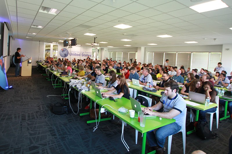
Brian McClendon addresses a rapt audience of Geo users
The summit was an opportunity for our most active contributing users to come together to learn, teach and share best practices with one another. A Map Maker workshop brought everyone up to speed on solid mapping practices and ways to add that next level of comprehensiveness to the map. Google reviewers also made the trip to Mountain View, CA to connect directly with users and give them the inside scoop on what goes into reviewing an incredible number of mapping edits each day, while offering insight to both new and experienced mappers. The user-generated unconference sessions also gave everyone a chance to troubleshoot, voice ideas, and brainstorm potential new product features with Googlers. There was also plenty of playtime, including an RC Car Scavenger Hunt, which had teams of summit attendees chasing remote controlled toy cars to points of interest across the Google campus. Ultimately, however, the event served as a forum for users to share their amazing and inspiring stories with fellow members of the Geo community.


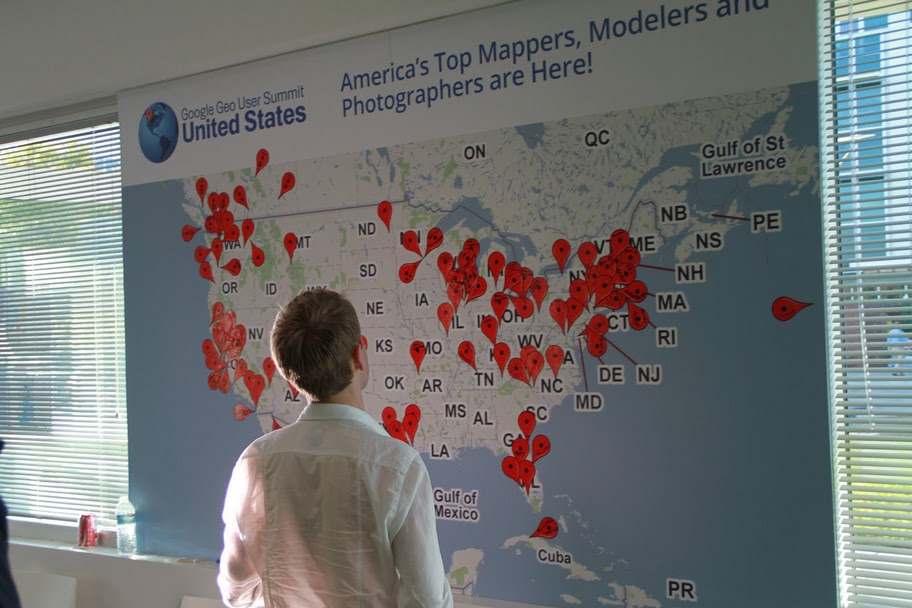
Geo users mark their place on the map
Hearing their stories and perspectives was definitely the highlight of the summit. For example, Sophia Sallas-Brookwell, an undergraduate at the University of Chicago, introduced her plan to implement Map Maker as a means of addressing the inequitable distribution of healthy food options in Chicago’s South Side. Educator Jon Walker described his extensive use of mapping and 3D modeling in his Gresham, Oregon classroom, and how he encourages his high school students to leave a thoughtful footprint in the world. Many other users also shared their tips, tricks, and motivations, igniting a noticeable enthusiasm among attendees.


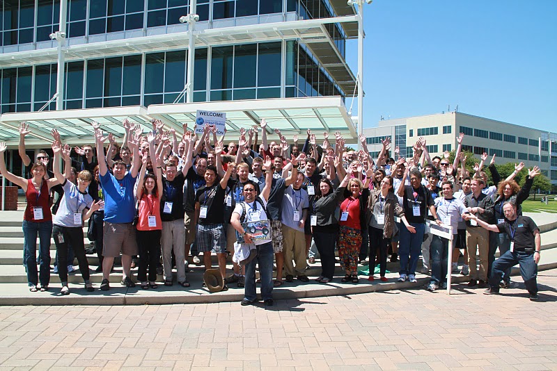
Googlers and Geo users join forces on Google’s Mountain View Crittenden Campus
If you weren’t among the crowd at this summer’s U.S. Geo User Summit, feel free to visit the event website, where you can browse photos of featured speakers, brainstorming sessions, and RC toy cars escaping into the sunset. Extensive session notes and presentations are also available. If you’re interested in attending future events, please see the Map Maker Events Calendar, 3D Events Calendar and Panoramio Events Calendar. This summit was just the beginning of an ongoing celebration of the passionate mappers, modelers, and photo contributors around the world.

Wednesday 10 August 2011

The Google Maps Kaleidoscope


I bet the first think you did when you first discovered Google Maps was to look at your house in satellite view. It has taken a while but finally you can now go a step better and view your house in kaleidoscope view.

#rorschmap uses the Google Maps API to create a kaleidoscope for any location on the Earth. Essentially the application displays the Google Maps satellite view of a location and, using the same principle of multiple reflection that you find in kaleidoscopes, creates an animated Rorschach test effect.

The result is pretty fantastic. You can even turn the automated animation off and drag and pan the map to create your own kaleidoscope views. You can even use the search function to create 'rorsch maps' for any location in the world.

GoogleMapsMania

Tuesday 9 August 2011

BBOX.ME: OSM to Google Earth

BBOX.ME (OSM to Google Earth) via FME

BBOX.ME (OSM to Google Earth) via FME
Left toolbar highlight large data download - red (large) amber medium and green is small data.
(OSM Servers will restrict large downloads automatically)

Take OpenStreetMap and via it's API, users can download an area of interest.

in this case:

"http:\api.openstreetmap.orgapi�.6map?bbox=-0.4994028225856829,53.73689294256218,-0.4839962145221512,53.74135397370099"

is requested from the OSM server via the OSM API.

OSM FME Workbench
FME Workbench for converting to Google (or 3D PDF etc)
BBOX.ME OSM to Google Earth
Output is A clean representation of OSM in Google Earth - but with 3D Building Extruded from the data. This can also be viewed in Streetview in Google Earth.

Extruded 3D Building (from Open Street Map) overlaid in Streetview in Google Earth
Extruded 3D Building (from Open Street Map) overlaid in Streetview in Google Earth.

This does use FME Desktop (a 30 day trail is available) which can convert the OSM files into Google Earth

Sunday 7 August 2011

Peace Memorial with Google Maps

This past March, we announced Street View imagery of the Hiroshima Peace Memorial. Known as the “Atomic Bomb Dome,” the Memorial bears witness to the devastation of nuclear war. The once proud pre-war structure nearly destroyed by the bomb still stands unrestored -- a monument to those lost and a powerful symbol of peace.

Yesterday in Japan, we went one step further, making new imagery of the interior of the Memorial available via its Place page. While millions have visited the Memorial, you can only safely view it from the outside, standing behind a fence, because of the extent of the damage.


View Larger Map
However iconic the Dome may be, it’s difficult to comprehend the magnitude and scope of the devastation from the outside of the building. But with the support of the Hiroshima city government, we gathered hi-resolution imagery that actually enables you to “walk” through the building room by room, using the same technology we’ve used to photograph other historic monuments around the world. The difference here is that while you can wander the gardens of Versailles or streets of Rome in person, the only way you can access the interior of the structure is digitally.

We launched this imagery in Japan on August 5th, one day before the 66th anniversary of the bombing of Hiroshima. You can access this collection via the Memorial’s Place page, or start exploring via this link. As with all of our special collections, we hope this imagery helps people around the world virtually travel to places they’d never otherwise have a chance to see.

Wednesday 3 August 2011

SAP, Google Earth and Google Maps integration


SAP is planning to add some new tools in the coming months to help integrate their business analytics software with Google Earth and Google Maps. With tens of billions of dollars in annual revenue, SAP is a massive company and this kind of integration will be incredibly useful for thousands of businesses around the world to get a better understanding of their data.


sap.jpg 

Given the widespread use of SAP and the volumes of data that companies have stored in it, the possiblities for geo-related use cases are incredible. Here are a few that SAP mentioned:
  • A telecom operator could use Google Earth to perform dropped-call analysis and pinpoint the geo-coordinates of faulty towers.
  • A state department of revenue could overlay household tax information on a map of the state and group it at the county level to track the highest and lowest tax bases.
  • A mortgage bank could perform risk assessment of its mortgage portfolio by overlaying foreclosure and default data with the location of loans on Google Maps.
  • A team of customer support representatives in a consumer packaged goods company could collaborate and pinpoint the location of consumer complaints within specific geographies and make a decision regarding how to address and prioritize resolution.
  • A theme park operator could use the Google Maps API Premier and get real-time traffic information on attractions to send rerouting messages to customers in order to improve satisfaction rates.
  • U.S. census data could be overlaid on a Google map of the country, grouped by state and drilled down on at the county level.
The new software isn't due out until later this year with the release of SAP's Business Objects 4.1, but they've already produced a video showing some of the features that will be included.

Tuesday 2 August 2011

New Ordnance Survey Leisure


New Ordnance Survey Leisure

Ordnance Survey New Get-a-Map
View weather and 1:25,000 scale [Explorer Range] Maps

bug: when panning with toolbar pan panning does not stop [FireFox 4.]


Experience a whole new world of online maps with Ordnance Survey getamap. Plot your own routes, print, save and share customised maps. If you’re looking for something new on your door step or planning a trip away...
  • Create and share routes and maps
  • Search for routes from other members or our featured brands
  • Print Ordnance Survey mapping
  • Find places of interest and attractions
  • Check the weather and local news.
  • upload gpx or kml files for creating routes
  • save as gpx to hand held gps unit (only garmin gps products supported)
  • get local weather, news,
Subscribe for £30 per year (but with a special launch price of £18 until 30th June 2011)

Full Screen Map
Unlimited A4 Maps at no extra cost (but have an A3 Printer!)
Unlimited Authored Routes at no extra cost

FAQ and Help
Digital Maps
http://www.shop.ordnancesurveyleisure.co.uk/products/digital-maps/digital-maps-for-personal-computer (these are at cost/paid for products other free alternative sites are available.)
For IPhone/Touch
They even sell clothes....

Monday 1 August 2011

StreetPilot for Windows Phone provides another option on the go


SP Windows logo Busy commuters and travelers now have another option for using easy-to-use Garmin navigation in their everyday activities. Available in the Windows Marketplace, Garmin StreetPilot for Windows Phone puts Garmin's intuitive interface right at your fingertips with flickable menu pages and theme color support designed specifically for Windows Phone. It's easy to look up addresses and services and get voice-prompted, turn-by-turn directions that speak street names to your destination. Garmin StreetPilot uses detailed City Navigator NT street maps of the U.S and Canada, featuring millions of points of interest, 2-D or 3-D map views and speed limits for most major roads. Garmin StreetPilot for Windows Phone uses the same great City Navigator NT maps available for Garmin’s nĂ¼vi product line without the need to ever download new data. There's no need to purchase or download map updates because data is updated regularly on the network.

SP Windows traffic SP Windows flight With Garmin StreetPilot for Windows Phone, you’ll have access to Google Local Search integrated with navigation so you easily can find new restaurants, businesses and more. You even can place calls directly from the search listing. You’ll also have access to current weather conditions and forecast details around your current location, destination or other locales. With the flight status feature, you’ll be able to look up flights by airport, airline or flight number, and get up-to-date arrival, departure and gate information.

SP Windows lane In addition to all of the other stress-relieving features, now there's no more guessing which lane you need to be in to make an upcoming turn. Lane Assist with Junction View guides you to the correct lane for an approaching turn or exit, making unfamiliar intersections and exits easy to navigate. It realistically displays road signs and junctions on your route along with arrows that indicate the proper lane for navigation.

In most metropolitan areas, you can steer clear of traffic with the integrated traffic updates, and you can simply touch the screen to view the traffic details. Receive alerts about traffic delays and road construction that lie ahead on your route along with an estimate of the delay.

Share This Post